
File:Map 4 - Croatia - Western Slavonia - September 1991 - January 1992.jpg

Size of this preview: 344 × 600 pixels. Other resolutions: 137 × 240 pixels | 275 × 480 pixels | 440 × 768 pixels | 587 × 1,024 pixels | 1,607 × 2,801 pixels.
Original file (1,607 × 2,801 pixels, file size: 1.39 MB, MIME type: image/jpeg)
| This is a file from the Wikimedia Commons. Information from its description page there is shown below. Commons is a freely licensed media file repository. You can help. |
Summary
| Description |
English: Map of front lines and military offensives in the western Slavonia in Croatia in September 1991-January 1992 period of the Croatian War of Independence. Balkan Battlegrounds Map 4. |
| Date | |
| Source | Balkan Battlegrounds: A Military History of the Yugoslav Conflict, 1990-1995, Diane Publishing Company, 2003, ISBN 0756729300, 9780756729301; (https://www.loc.gov/item/2010588135) |
| Author | Central Intelligence Agency |


Licensing
| This image is a work of a Central Intelligence Agency employee, taken or made as part of that person's official duties. As a Work of the United States Government, this image or media is in the public domain in the United States.
|

|
File history
Click on a date/time to view the file as it appeared at that time.
| Date/Time | Thumbnail | Dimensions | User | Comment | |
|---|---|---|---|---|---|
| current | 02:43, 26 November 2019 |  | 1,607 × 2,801 (1.39 MB) | UserNameSRB | Croped |
| 22:01, 14 November 2019 |  | 2,181 × 3,387 (778 KB) | UserNameSRB | Better resolution | |
| 16:09, 9 May 2013 | 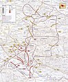 | 684 × 831 (472 KB) | Tomobe03 | User created page with UploadWizard |
File usage
The following pages on the English Wikipedia use this file (pages on other projects are not listed):
Global file usage
The following other wikis use this file:
- Usage on es.wikipedia.org
- Usage on fi.wikipedia.org
- Usage on hu.wikipedia.org
- Usage on pt.wikipedia.org
- Usage on sh.wikipedia.org
- Usage on sr.wikipedia.org
- Usage on www.wikidata.org