
File:Manhattan NYC OpenStreetMap 2023-08-21.png

Original file (5,210 × 11,040 pixels, file size: 33.15 MB, MIME type: image/png)
| This is a file from the Wikimedia Commons. Information from its description page there is shown below. Commons is a freely licensed media file repository. You can help. |
Summary
| Description |
English: OpenStreetMap map (as of August 21, 2023) of Manhattan Island, New York City.
Manhattan Island, with its length of 21 km (13 mi) and its width of 3.7 km (2.3 mi), at its widest point, was shaped by the Commissioners' Plan of 1811, which laid out a grid plan over most of the island: 30 m (100 feet) wide avenues running north-south, and 18 m (60 feet) wide numbered streets running east–west, with about 61 m (200 feet) between each pair of streets, resulting in each combined street and block adding up to about 79 m (260 feet), so there are almost exactly 20 blocks per mile. Fifteen crosstown streets were designated as 30 m (100 feet) wide: 14th, 23rd, 34th, 42nd, 57th, 72nd, 79th, 86th, 96th, 106th, 116th, 125th, 135th, 145th and 155th streets. Later, between 1857 and 1876, Central Park was added. Since 1951, the island hosts the headquarters of the United Nations. This map shows Manhattan as of August 21, 2023, according to OpenStreetMap.Español: Mapa de OpenStreetMap (a fecha de 21 de agosto de 2023) de la isla de Manhattan, en la ciudad de Nueva York
La isla de Manhattan, con una longitud de 21 km (13 millas) y una anchura de 3,7 km (2,3 millas), en su punto más ancho, fue moldeada por el Plan de los Comisionados de 1811, que trazó un plano de cuadrícula sobre la mayor parte de la isla: avenidas de 30 m (100 pies) de ancho que van de norte a sur y calles numeradas de 18 m (60 pies) de ancho que van de este a oeste, con aproximadamente 61 m (200 pies) entre cada par de calles, lo que da como resultado que cada calle y manzana combinadas sumen unos 79 m (260 pies), de modo que hay casi exactamente 20 manzanas por cada milla. Quince de las calles que cruzan la ciudad fueron designadas para tener 30 m (100 pies) de ancho: se trata de las calles 14, 23, 34, 42, 57, 72, 79, 86, 96, 106, 116, 125, 135, 145 y 155. Posteriormente, entre 1857 y 1876, fue añadido Central Park. Desde 1951, la isla alberga la sede de las Naciones Unidas. Este mapa muestra Manhattan a fecha de 21 de agosto de 2023, según OpenStreetMap. |
| Date | |
| Source | https://www.openstreetmap.org |
| Author | OpenStreetMap |
|
|
Do not upload new revisions over this file version without my explicit consent. Instead, use the possibility to upload a new version under a new name and tag it as a derivative or extract of this file.
|

Licensing
- You are free:
- to share – to copy, distribute and transmit the work
- to remix – to adapt the work
- Under the following conditions:
- attribution – You must give appropriate credit, provide a link to the license, and indicate if changes were made. You may do so in any reasonable manner, but not in any way that suggests the licensor endorses you or your use.
| This work contains information from OpenStreetMap, which is made available under the Open Database License (ODbL).
The ODbL does not require any particular license for maps produced from ODbL data. Prior to 1 August 2020, map tiles produced by the OpenStreetMap Foundation were licensed under the CC-BY-SA-2.0 license. Maps produced by other people may be subject to other licences. |
File history
Click on a date/time to view the file as it appeared at that time.
| Date/Time | Thumbnail | Dimensions | User | Comment | |
|---|---|---|---|---|---|
| current | 19:56, 21 August 2023 | 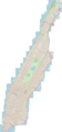 | 5,210 × 11,040 (33.15 MB) | MGeog2022 | Uploaded a work by OpenStreetMap from https://www.openstreetmap.org with UploadWizard |
File usage
Global file usage
The following other wikis use this file:
- Usage on es.wikipedia.org
- Usage on fr.wikipedia.org
- Usage on it.wikipedia.org