
File:Mafia Island marine chart 1875-77 -50+70.png

Original file (1,378 × 1,868 pixels, file size: 1.34 MB, MIME type: image/png)
| This is a file from the Wikimedia Commons. Information from its description page there is shown below. Commons is a freely licensed media file repository. You can help. |
Summary
| Description |
English: marine chart of Mafia Island, Pwami Region, Tanzania, Indian Ocean *-50 % brightness *+70% contrast |
| Date | between 1875 and 1877 |
| Source | http://greif.uni-greifswald.de/geogreif/geogreif-content/upload/SeekarteM8.jpg |
| Author | W J L Wharton |
Licensing
|
This work is in the public domain in its country of origin and other countries and areas where the copyright term is the author's life plus 70 years or fewer.
| |
| This file has been identified as being free of known restrictions under copyright law, including all related and neighboring rights. | |
File history
Click on a date/time to view the file as it appeared at that time.
| Date/Time | Thumbnail | Dimensions | User | Comment | |
|---|---|---|---|---|---|
| current | 18:35, 9 March 2010 | 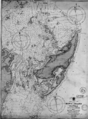 | 1,378 × 1,868 (1.34 MB) | Ratzer | {{Information |Description={{en|1=marine chart of Mafia Island, Pwami Region, Tanzania, Indian Ocean}} |Source=http://greif.uni-greifswald.de/geogreif/geogreif-content/upload/SeekarteM8.jpg |Author=W J L Wharton |Date=1875-77 |Permission= |other_versions= |
File usage
Global file usage
The following other wikis use this file:
- Usage on ar.wikipedia.org
- Usage on avk.wikipedia.org
- Usage on de.wikipedia.org
- Usage on el.wikipedia.org
- Usage on hy.wikipedia.org
- Usage on ja.wikipedia.org
- Usage on pnb.wikipedia.org
- Usage on ru.wikipedia.org
- Usage on ur.wikipedia.org