
File:Madison Square North Historic District map.jpg

No higher resolution available.
Madison_Square_North_Historic_District_map.jpg (665 × 458 pixels, file size: 38 KB, MIME type: image/jpeg)
| This is a file from the Wikimedia Commons. Information from its description page there is shown below. Commons is a freely licensed media file repository. You can help. |
Summary
| Description | Map of the Madison Square North Historic District in Manhattan, New York City |
| Date | |
| Source | Own work |
| Author | Beyond My Ken |
| Object location | | View this and other nearby images on: OpenStreetMap |
|---|
Licensing
| I, the copyright holder of this work, release this work into the public domain. This applies worldwide. In some countries this may not be legally possible; if so: I grant anyone the right to use this work for any purpose, without any conditions, unless such conditions are required by law. |
File history
Click on a date/time to view the file as it appeared at that time.
| Date/Time | Thumbnail | Dimensions | User | Comment | |
|---|---|---|---|---|---|
| current | 00:38, 20 April 2010 | 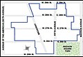 | 665 × 458 (38 KB) | Beyond My Ken | == Summary == {{Information |Description= Map of the Madison Square North Historic District in Manhattan, New York City |Source= {{own}} |Date= 2010-04-19 |Author= Beyond My Ken ([[User talk:Beyond My Ken|<span class="signature-talk |
File usage
The following pages on the English Wikipedia use this file (pages on other projects are not listed):
Global file usage
The following other wikis use this file:
- Usage on zh.wikipedia.org