
File:MBTA Commuter Rail Map.svg

Size of this PNG preview of this SVG file: 600 × 600 pixels. Other resolutions: 240 × 240 pixels | 480 × 480 pixels | 768 × 768 pixels | 1,024 × 1,024 pixels | 2,048 × 2,048 pixels | 1,760 × 1,760 pixels.
Original file (SVG file, nominally 1,760 × 1,760 pixels, file size: 2.7 MB)
| This is a file from the Wikimedia Commons. Information from its description page there is shown below. Commons is a freely licensed media file repository. You can help. |
Summary
| Description |
English: Diagram of the MBTA Commuter Rail system |
|||||
| Date | 23 January 2023 (latest version) | |||||
| Source | Own work | |||||
| Author |
Original map by The Port of Authority Updates by Pi.1415926535 |
|||||
| SVG development | This W3C-invalid vector image was created with Inkscape.
|


Licensing
I, the copyright holder of this work, hereby publish it under the following license:
This file is licensed under the Creative Commons Attribution-Share Alike 3.0 Unported license.
- You are free:
- to share – to copy, distribute and transmit the work
- to remix – to adapt the work
- Under the following conditions:
- attribution – You must give appropriate credit, provide a link to the license, and indicate if changes were made. You may do so in any reasonable manner, but not in any way that suggests the licensor endorses you or your use.
- share alike – If you remix, transform, or build upon the material, you must distribute your contributions under the same or compatible license as the original.
File history
Click on a date/time to view the file as it appeared at that time.
| Date/Time | Thumbnail | Dimensions | User | Comment | |
|---|---|---|---|---|---|
| current | 05:02, 18 December 2023 |  | 1,760 × 1,760 (2.7 MB) | Pi.1415926535 | Lynn reopened |
| 06:24, 23 January 2023 |  | 1,760 × 1,760 (2.7 MB) | Pi.1415926535 | various changes for clarity; P/CF open | |
| 03:03, 23 October 2022 |  | 1,760 × 1,760 (2.71 MB) | Pi.1415926535 | separate Old Colony Lines | |
| 06:58, 6 October 2022 |  | 1,760 × 1,760 (2.7 MB) | Pi.1415926535 | Update: South Coast Rail alignment, Oak Grove, closed stations, station names, etc | |
| 19:57, 14 March 2020 |  | 1,760 × 1,760 (2.6 MB) | Pi.1415926535 | Actually update for Foxboro service; SCR stations still need name fixes | |
| 15:19, 14 March 2020 | 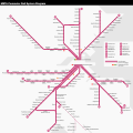 | 1,760 × 1,760 (2.6 MB) | Simtropolitan | Removed old date in upper right corner; map has been continuously updated | |
| 06:50, 26 February 2019 |  | 1,760 × 1,760 (2.6 MB) | Pi.1415926535 | Update Fairmount Line stations; add Silver Line dot at Chelsea | |
| 15:39, 1 August 2017 |  | 1,760 × 1,760 (2.66 MB) | Simtropolitan | Boston Landing added | |
| 00:43, 24 November 2016 |  | 1,650 × 1,650 (2.47 MB) | Pi.1415926535 | Temporary version (still needs other fixes) for Wachusett opening | |
| 06:50, 24 December 2012 |  | 1,650 × 1,650 (2.49 MB) | Pi.1415926535 | Preferred dot lcoations |
File usage
The following pages on the English Wikipedia use this file (pages on other projects are not listed):
Global file usage
The following other wikis use this file:
- Usage on de.wikipedia.org
- Usage on es.wikipedia.org
- Usage on id.wikipedia.org
- Usage on it.wikipedia.org
- Usage on ko.wikipedia.org
- Usage on www.wikidata.org
- Usage on zh-yue.wikipedia.org
- Usage on zh.wikipedia.org