
File:Luth dranyen (musée d'ethnographie, Neuchâtel, Suisse) (28873179047).jpg

Original file (4,352 × 2,448 pixels, file size: 2.43 MB, MIME type: image/jpeg)
| This is a file from the Wikimedia Commons. Information from its description page there is shown below. Commons is a freely licensed media file repository. You can help. |
Summary
| Description |
Luth dranyen Vitrine des objets profanes du Bhoutan, offerts au musée d'ethnographie de Neuchâtel par Sa Majesté Jigme Dorji Wangchuk, roi du Bhoutan en 1968 le dranyen sur Wikipedia <aexternal free">https://fr.wikipedia.org/wiki/Dranyen" rel="noreferrer nofollow">fr.wikipedia.org/wiki/Dranyen</a>
La vitrine Toit du Monde au musée de la musique de Céret (photo dalbera) <anofollow" class="external free">https://www.flickr.com/photos/dalbera/8778174363/in/album-72157648269886021/">www.flickr.com/photos/dalbera/8778174363/in/album-7215764...</a> |
| Date | |
| Source | Luth dranyen (musée d'ethnographie, Neuchâtel, Suisse) |
| Author | Jean-Pierre Dalbéra from Paris, France |
| Camera location | | View this and other nearby images on: OpenStreetMap |
|---|
Licensing
- You are free:
- to share – to copy, distribute and transmit the work
- to remix – to adapt the work
- Under the following conditions:
- attribution – You must give appropriate credit, provide a link to the license, and indicate if changes were made. You may do so in any reasonable manner, but not in any way that suggests the licensor endorses you or your use.
| This image was originally posted to Flickr by dalbera at https://flickr.com/photos/72746018@N00/28873179047 (archive). It was reviewed on 16 October 2019 by FlickreviewR 2 and was confirmed to be licensed under the terms of the cc-by-2.0. |
File history
Click on a date/time to view the file as it appeared at that time.
| Date/Time | Thumbnail | Dimensions | User | Comment | |
|---|---|---|---|---|---|
| current | 19:13, 16 October 2019 | 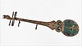 | 4,352 × 2,448 (2.43 MB) | B2Belgium | Transferred from Flickr via #flickr2commons |