
File:Locator map Sudan North Kurdufan (CPA).png

No higher resolution available.
Locator_map_Sudan_North_Kurdufan_(CPA).png (683 × 600 pixels, file size: 142 KB, MIME type: image/png)
| This is a file from the Wikimedia Commons. Information from its description page there is shown below. Commons is a freely licensed media file repository. You can help. |
| Description |
English: Locator map of North Kurdufan state, in the Kurdufan region — in post-2011 Sudan.
|
| Date | |
| Source | |
| Author | Сержант Кандыба |
| Permission (Reusing this file) |
I, the copyright holder of this work, hereby publish it under the following license: This file is licensed under the Creative Commons Attribution-Share Alike 3.0 Unported license.
|
File history
Click on a date/time to view the file as it appeared at that time.
| Date/Time | Thumbnail | Dimensions | User | Comment | |
|---|---|---|---|---|---|
| current | 10:46, 10 July 2011 | 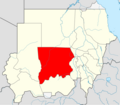 | 683 × 600 (142 KB) | Пакко | without south sudan |
| 18:18, 8 February 2011 | 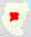 | 480 × 568 (126 KB) | Пакко | upg | |
| 07:06, 16 January 2011 |  | 507 × 600 (84 KB) | Сержант Кандыба | {{Information |Description={{en|1={{Information |Description=Locator map according to Protocol of Comprehensive Peace Agreement (territory of West Kordofan divided between North and South Kordofan States) |Source=*Vector map from [[:File:Sudan location m |
File usage
The following pages on the English Wikipedia use this file (pages on other projects are not listed):
Global file usage
The following other wikis use this file:
- Usage on ar.wikipedia.org
- Usage on arz.wikipedia.org
- Usage on ast.wikipedia.org
- Usage on azb.wikipedia.org
- Usage on bg.wikipedia.org
- Usage on ca.wikipedia.org
- Usage on da.wikipedia.org
- Usage on eo.wikipedia.org
- Usage on ha.wikipedia.org
- Usage on id.wikipedia.org
- Usage on ig.wikipedia.org
- Usage on pl.wikipedia.org
- Usage on pl.wikivoyage.org
- Usage on ro.wikipedia.org
- Usage on sv.wikipedia.org
- Usage on ts.wikipedia.org
- Usage on ur.wikipedia.org
- Usage on www.wikidata.org
- Usage on yo.wikipedia.org
- Usage on zu.wikipedia.org