
File:Leeward Islands (Society Islands) topographic map-fr.svg

Size of this PNG preview of this SVG file: 800 × 400 pixels. Other resolutions: 320 × 160 pixels | 640 × 320 pixels | 1,024 × 512 pixels | 1,280 × 640 pixels | 2,560 × 1,280 pixels | 2,000 × 1,000 pixels.
Original file (SVG file, nominally 2,000 × 1,000 pixels, file size: 1.6 MB)
| This is a file from the Wikimedia Commons. Information from its description page there is shown below. Commons is a freely licensed media file repository. You can help. |
Summary
| Description | |
| Date | |
| Source |
Œuvre personnelle.
Données :
Logiciels utilisés :
Autres informations :
|
| Author | Sardon |
| Other versions |
     |
| This SVG file contains embedded text that can be translated into your language, using any capable SVG editor, text editor or the SVG Translate tool. For more information see: About translating SVG files. |
This W3C-unspecified vector image was created with Inkscape .
Licensing
| I, the copyright holder of this work, release this work into the public domain. This applies worldwide. In some countries this may not be legally possible; if so: I grant anyone the right to use this work for any purpose, without any conditions, unless such conditions are required by law. |
File history
Click on a date/time to view the file as it appeared at that time.
| Date/Time | Thumbnail | Dimensions | User | Comment | |
|---|---|---|---|---|---|
| current | 16:14, 23 November 2008 |  | 2,000 × 1,000 (1.6 MB) | Sardon | {{Information |Description= |Source= |Date= |Author= |Permission= |other_versions= }} |
| 20:14, 16 November 2008 |  | 2,000 × 1,000 (1.62 MB) | Sardon | {{Information |Description= |Source= |Date= |Author= |Permission= |other_versions= }} | |
| 20:12, 16 November 2008 |  | 2,000 × 1,000 (674 KB) | Sardon | {{Information |Description= |Source= |Date= |Author= |Permission= |other_versions= }} | |
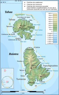
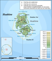
| 10:16, 9 November 2008 |  | 2,455 × 1,743 (536 KB) | Sardon | {{Information |Description={{en|1=Topographic map in French of the islands of Huahine, Raiatea, Tahaa, Bora Bora and Tupai, Society Islands, French Polynesia.}} {{fr|1=Carte top |
File usage
The following pages on the English Wikipedia use this file (pages on other projects are not listed):
Global file usage
The following other wikis use this file:
- Usage on af.wikipedia.org
- Usage on als.wikipedia.org
- Usage on ar.wikipedia.org
- Usage on br.wikipedia.org
- Usage on eo.wikipedia.org
- Usage on es.wikipedia.org
- Usage on eu.wikipedia.org
- Usage on fi.wikipedia.org
- Usage on fr.wikipedia.org
- Géographie de la Polynésie française
- Archipel de la Société
- Îles Sous-le-Vent (Polynésie)
- Utilisateur:Sardon
- Wikipédia:Atelier graphique/Cartes/Archives/novembre 2008
- Liste des souverains des îles Raiatea, Huahine et Bora-Bora
- Wikipédia:Atelier graphique/Cartes/Archives/décembre 2015
- Utilisateur:Exp JC/Brouillon
- Relations entre la France et les pays et territoires d'Océanie
- Usage on gl.wikipedia.org
- Usage on hu.wikipedia.org
- Usage on mk.wikipedia.org
- Usage on nl.wikipedia.org
- Usage on no.wikipedia.org
- Usage on pl.wikipedia.org
- Usage on pt.wikipedia.org
- Usage on ru.wikipedia.org
- Usage on tr.wikipedia.org
- Usage on ty.wikipedia.org
- Usage on zh-yue.wikipedia.org
- Usage on zh.wikipedia.org