
File:Lassen VNP map.png

No higher resolution available.
Lassen_VNP_map.png (373 × 277 pixels, file size: 41 KB, MIME type: image/png)
| This is a file from the Wikimedia Commons. Information from its description page there is shown below. Commons is a freely licensed media file repository. You can help. |
Summary
| Description | Map of Lassen area showing hydrothermal features (red dots) and volcanic feature or remnant (yellow cones). Also shown is the outline of Brokeoff Volcano. |
| Date | |
| Source | en:Lassen Volcanic National Park |
| Author | en:User:Mav |
| Permission (Reusing this file) |
This image is a work of a United States Geological Survey employee, taken or made during the course of the person's official duties. As a work of the United States Government, the image is in the public domain. For more information, see the USGS copyright policy. |
Licensing
| This file is licensed under the Creative Commons Attribution-Share Alike 3.0 Unported license. Subject to disclaimers. | ||
| ||
| This licensing tag was added to this file as part of the GFDL licensing update. |

|
Permission is granted to copy, distribute and/or modify this document under the terms of the GNU Free Documentation License, Version 1.2 or any later version published by the Free Software Foundation; with no Invariant Sections, no Front-Cover Texts, and no Back-Cover Texts. A copy of the license is included in the section entitled GNU Free Documentation License. Subject to disclaimers. |
File history
Click on a date/time to view the file as it appeared at that time.
| Date/Time | Thumbnail | Dimensions | User | Comment | |
|---|---|---|---|---|---|
| current | 16:40, 23 February 2008 | 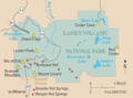 | 373 × 277 (41 KB) | Davin7 | {{Information |Description= Map of Lassen area showing hydrothermal features (red dots) and volcanic feature or remnant (yellow cones). Also shown is the outline of Brokeoff Volcano. |Source= en:Lassen Volcanic National Park |Date= 18 May 2004 |Autho |
File usage
The following pages on the English Wikipedia use this file (pages on other projects are not listed):
Global file usage
The following other wikis use this file:
- Usage on he.wikipedia.org
- Usage on is.wikipedia.org
- Usage on nl.wikipedia.org