
File:Kuril-Islands-Northern-Territories-of-Japan-Map.png

Size of this preview: 800 × 411 pixels. Other resolutions: 320 × 164 pixels | 640 × 328 pixels | 1,024 × 525 pixels | 1,787 × 917 pixels.
Original file (1,787 × 917 pixels, file size: 415 KB, MIME type: image/png)
| This is a file from the Wikimedia Commons. Information from its description page there is shown below. Commons is a freely licensed media file repository. You can help. |

|
This map image could be re-created using vector graphics as an SVG file. This has several advantages; see Commons:Media for cleanup for more information. If an SVG form of this image is available, please upload it and afterwards replace this template with
{{vector version available|new image name}}.
It is recommended to name the SVG file “Kuril-Islands-Northern-Territories-of-Japan-Map.svg”—then the template Vector version available (or Vva) does not need the new image name parameter. |
Summary
| Description |
English: Map of the Northern Territories of Japan. It includes Kunashiri, the Habomai islands, Etorofu and Shikotan. It is claimed as part of Nemuro Subprefecture. It features the Japanese districts: 1. Shikotan, 2. Tomari, 3. Ruyobetsu, 4. Rubetsu, 5. Shana, 6. Shibetoro. This map has the Japanese island names. Created with DEMIS World Map Server.
日本語: 日本の北方地域の地図(千島列島)。 歯舞群島、色丹島、国後島、択捉島が含まれています。根室国の一部として主張されています。根室振興局の自治体: 1. 色丹村、2.泊村、3. 留夜別村、4.留別村、5.紗那村、6. 蘂取村
|
||||
| Date | |||||
| Source | https://www.demis.nl/products/web-map-server/examples/ | ||||
| Author |
Created with DEMIS World Map Server.
|
Licensing
| This file is made available under the Creative Commons CC0 1.0 Universal Public Domain Dedication. | |
| The person who associated a work with this deed has dedicated the work to the public domain by waiving all of their rights to the work worldwide under copyright law, including all related and neighboring rights, to the extent allowed by law. You can copy, modify, distribute and perform the work, even for commercial purposes, all without asking permission.
|
File history
Click on a date/time to view the file as it appeared at that time.
| Date/Time | Thumbnail | Dimensions | User | Comment | |
|---|---|---|---|---|---|
| current | 13:27, 15 October 2019 | 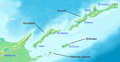 | 1,787 × 917 (415 KB) | Artanisen | Made the Nemuro Province Japanese district names easier in English: 1. Shikotan, 2. Tomari, 3. Ruyobetsu, 4. Rubetsu, 5. Shana, 6. Shibetoro. |
| 11:18, 15 October 2019 | 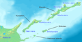 | 1,787 × 917 (429 KB) | Artanisen | Improved text size. Made Japanese names easier (Kunashiri, Shikotan, Habomai islands, Etorofu). | |
| 05:52, 15 October 2019 |  | 1,787 × 917 (440 KB) | Artanisen | User created page with UploadWizard |
File usage
The following pages on the English Wikipedia use this file (pages on other projects are not listed):
Global file usage
The following other wikis use this file:
- Usage on ceb.wikipedia.org
- Usage on eo.wikipedia.org
- Usage on fr.wikipedia.org
- Usage on hu.wikipedia.org
- Usage on id.wikipedia.org
- Usage on it.wikipedia.org
- Usage on mk.wikipedia.org
- Usage on simple.wikipedia.org
- Usage on sl.wikipedia.org
- Usage on th.wikipedia.org
- Usage on tr.wikipedia.org
- Usage on uk.wikipedia.org