
File:Kherson military–civilian administration hatched.svg

Size of this PNG preview of this SVG file: 800 × 586 pixels. Other resolutions: 320 × 235 pixels | 640 × 469 pixels | 1,024 × 750 pixels | 1,280 × 938 pixels | 2,560 × 1,876 pixels | 1,430 × 1,048 pixels.
Original file (SVG file, nominally 1,430 × 1,048 pixels, file size: 140 KB)
| This is a file from the Wikimedia Commons. Information from its description page there is shown below. Commons is a freely licensed media file repository. You can help. |
Summary
| Description |
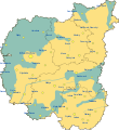
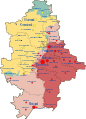
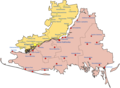
English: Map of Russia's Khersonskaya Oblast, made up of the whole of Kherson Oblast & parts of Mykolaiv Oblast in Ukraine. |
| Date | |
| Source | Own work, based on Russian Occupation of Kherson Oblast.svg |
| Author | Physeters, hatching by Antimuonium |
| Other versions |
[]
|


Licensing
I, the copyright holder of this work, hereby publish it under the following license:
This file is licensed under the Creative Commons Attribution-Share Alike 4.0 International license.
- You are free:
- to share – to copy, distribute and transmit the work
- to remix – to adapt the work
- Under the following conditions:
- attribution – You must give appropriate credit, provide a link to the license, and indicate if changes were made. You may do so in any reasonable manner, but not in any way that suggests the licensor endorses you or your use.
- share alike – If you remix, transform, or build upon the material, you must distribute your contributions under the same or compatible license as the original.
File history
Click on a date/time to view the file as it appeared at that time.
| Date/Time | Thumbnail | Dimensions | User | Comment | |
|---|---|---|---|---|---|
| current | 07:00, 5 December 2022 |  | 1,430 × 1,048 (140 KB) | Physeters | update |
| 05:32, 28 September 2022 |  | 1,430 × 1,048 (150 KB) | Antimuonium | Uploaded own work with UploadWizard |
File usage
The following pages on the English Wikipedia use this file (pages on other projects are not listed):
Global file usage
The following other wikis use this file:
- Usage on de.wikipedia.org
- Usage on fr.wikipedia.org
- Usage on hu.wikipedia.org
- Usage on it.wikipedia.org
- Usage on ja.wikipedia.org
- Usage on pt.wikipedia.org