
File:Kent city wards streets.png

Size of this preview: 621 × 600 pixels. Other resolutions: 248 × 240 pixels | 497 × 480 pixels | 795 × 768 pixels | 1,060 × 1,024 pixels | 1,537 × 1,485 pixels.
Original file (1,537 × 1,485 pixels, file size: 892 KB, MIME type: image/png)
| This is a file from the Wikimedia Commons. Information from its description page there is shown below. Commons is a freely licensed media file repository. You can help. |
| Description |
English: Map of Kent, Ohio showing political wards, selected streets, and boundaries of the Kent State University campus as of 2012 using the U.S. Census Bureau 2010 Boundary and Annexation Survey map as a base. Colors, street names, and other markings added by JonRidinger using data from the Portage County Auditor. |
|||
| Date | ||||
| Source | ||||
| Author |
|
|||
| Permission (Reusing this file) |
I, the copyright holder of this work, hereby publish it under the following licenses: This file is licensed under the Creative Commons Attribution 3.0 Unported license.
You may select the license of your choice. |

File history
Click on a date/time to view the file as it appeared at that time.
| Date/Time | Thumbnail | Dimensions | User | Comment | |
|---|---|---|---|---|---|
| current | 21:46, 2 October 2012 |  | 1,537 × 1,485 (892 KB) | JonRidinger | Corrected city boundaries based on county auditor's listings |
| 01:28, 17 February 2012 |  | 1,537 × 1,485 (884 KB) | JonRidinger | Updated boundaries (effective March 2012) | |
| 03:01, 29 August 2010 |  | 1,537 × 1,485 (817 KB) | JonRidinger | Minor corrections and modifications | |
| 07:30, 27 August 2010 | 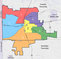 | 1,537 × 1,485 (754 KB) | JonRidinger | Made map using PD Census Bureau map as the base map | |
| 06:43, 3 September 2009 |  | 900 × 675 (394 KB) | JonRidinger | Updated boundaries | |
| 07:07, 15 August 2009 |  | 900 × 675 (671 KB) | JonRidinger | {{Information |Description={{en|1=Map showing the wards and selected streets of Kent, Ohio as of 2006. Made from original map at www.kentohio.org (City of Kent website). Colors, street names, and other markings added by JonRidinger.}} | |
File usage
The following pages on the English Wikipedia use this file (pages on other projects are not listed):