
File:Keighley railway station (geograph 7027473).jpg

Size of this preview: 800 × 600 pixels. Other resolutions: 320 × 240 pixels | 640 × 480 pixels | 1,024 × 768 pixels.
Original file (1,024 × 768 pixels, file size: 1.17 MB, MIME type: image/jpeg)
| This is a file from the Wikimedia Commons. Information from its description page there is shown below. Commons is a freely licensed media file repository. You can help. |
Summary
| Description |
English: Looking towards the ramp which gives access to platforms 1 and 2 serving the Airedale line's trains, locally to Skipton and Leeds, with longer-distance services to Morecambe and Carlisle. The Keighley and Worth Valley Railway's northern terminus is to the left of this shot. |
| Date | |
| Source | From geograph.org.uk |
| Author | Paul Harrop |
| Permission (Reusing this file) |
Creative Commons Attribution Share-alike license 2.0 |
| Attribution (required by the license) | Paul Harrop / Keighley railway station / |
| Camera location | | View this and other nearby images on: OpenStreetMap |
|---|
| Object location | | View this and other nearby images on: OpenStreetMap |
|---|
Licensing

|
This image was taken from the Geograph project collection. See this photograph's page on the Geograph website for the photographer's contact details. The copyright on this image is owned by Paul Harrop and is licensed for reuse under the Creative Commons Attribution-ShareAlike 2.0 license.
|
This file is licensed under the Creative Commons Attribution-Share Alike 2.0 Generic license.
Attribution: Paul Harrop
- You are free:
- to share – to copy, distribute and transmit the work
- to remix – to adapt the work
- Under the following conditions:
- attribution – You must give appropriate credit, provide a link to the license, and indicate if changes were made. You may do so in any reasonable manner, but not in any way that suggests the licensor endorses you or your use.
- share alike – If you remix, transform, or build upon the material, you must distribute your contributions under the same or compatible license as the original.
File history
Click on a date/time to view the file as it appeared at that time.
| Date/Time | Thumbnail | Dimensions | User | Comment | |
|---|---|---|---|---|---|
| current | 19:48, 19 April 2022 | 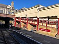 | 1,024 × 768 (1.17 MB) | Chocolateediter | == {{int:filedesc}} == {{Information |Description={{en|1= Looking towards the ramp which gives access to platforms 1 and 2 serving the Airedale line's trains, locally to Skipton and Leeds, with longer-distance services to Morecambe and Carlisle. The Keighley and Worth Valley Railway's northern terminus is to the left of this shot.}} |Source=From [https://www.geograph.org.uk/photo/7027473 geograph.org.uk] |Date=2021-11-21 |Author=[https://www.geograph.org.uk/profile/13364 Paul Harrop] |Permiss... |
File usage
The following pages on the English Wikipedia use this file (pages on other projects are not listed):