
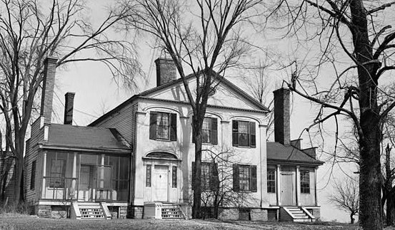
File:Judge Nathan Roberts House, State Highway 5, Canastota vicinity (Madison County, New York).jpg
No higher resolution available.
Judge_Nathan_Roberts_House,_State_Highway_5,_Canastota_vicinity_(Madison_County,_New_York).jpg (553 × 323 pixels, file size: 97 KB, MIME type: image/jpeg)
| This is a file from the Wikimedia Commons. Information from its description page there is shown below. Commons is a freely licensed media file repository. You can help. |
|
This is an image of a place or building that is listed on the National Register of Historic Places in the United States of America. Its reference number is 86001305. |
| Description |
English: Judge Nathan Roberts House, State Highway 5, Canastota vicinity (Madison County, New York)
cropped |
|||||
| Date | ||||||
| Source | http://memory.loc.gov/cgi-bin/displayPhoto.pl?path=/pnp/habshaer/ny/ny0200/ny0262/photos&topImages=117115pr.jpg&topLinks=117115pv.jpg,117115pu.tif&title=1.%20%20Historic%20American%20Buildings%20Survey,%20M.E.%20Granger,%20Photographer%20Mar.%2028,%201934,%20VIEW%20FROM%20SOUTH%20(FRONT).%3cbr%3eHABS%20NY,27-CANA.V,1-1&displayProfile=0 | |||||
| Author | M.E. Granger, Photographer | |||||
| Permission (Reusing this file) |
|

| Object location | | View this and other nearby images on: OpenStreetMap |
|---|
File history
Click on a date/time to view the file as it appeared at that time.
| Date/Time | Thumbnail | Dimensions | User | Comment | |
|---|---|---|---|---|---|
| current | 17:25, 2 August 2009 |  | 553 × 323 (97 KB) | KudzuVine | {{Information |Description={{en|1=Judge Nathan Roberts House, State Highway 5, Canastota vicinity (Madison County, New York) cropped {{PD-USGov-Interior-HABS|NY,27-CANA.V,1-1}}}} |Source=http://memory.loc.gov/cgi-bin/displayPhoto.pl?path=/pnp/habshaer/ny/ |
File usage
The following pages on the English Wikipedia use this file (pages on other projects are not listed):
Global file usage
The following other wikis use this file:
- Usage on ar.wikipedia.org
- Usage on ca.wikipedia.org
- Usage on ceb.wikipedia.org
- Usage on cy.wikipedia.org
- Usage on es.wikipedia.org
- Usage on eu.wikipedia.org
- Usage on fr.wikipedia.org
- Usage on ht.wikipedia.org
- Usage on it.wikipedia.org
- Usage on lld.wikipedia.org
- Usage on pl.wikipedia.org
- Usage on ru.wikipedia.org
- Usage on sh.wikipedia.org
- Usage on sr.wikipedia.org
- Usage on uk.wikipedia.org
- Usage on www.wikidata.org