
File:Jammu & Kashmir Distrikte.svg

Size of this PNG preview of this SVG file: 800 × 479 pixels. Other resolutions: 320 × 191 pixels | 640 × 383 pixels | 1,024 × 613 pixels | 1,280 × 766 pixels | 2,560 × 1,531 pixels | 1,090 × 652 pixels.
Original file (SVG file, nominally 1,090 × 652 pixels, file size: 153 KB)
| This is a file from the Wikimedia Commons. Information from its description page there is shown below. Commons is a freely licensed media file repository. You can help. |
Summary
| Description |
Deutsch: Distrikte von Jammu und Kashmir (2015). Achtung: die Karte gibt nur eine grobe Übersicht. Die Distriktgrenzen sind leider nur ungenau, aufgrund mangelhafter zur Verfügung stehender Karten.
Beanspruchte Gebiete:
English: District map of Jammu and Kashmir in 2015. Note: the district borders are not very precise due to lack of detailed map sources. This map can only give a rough overview. Claimed territories:
|
||
| Date | |||
| Source |
|
||
| Author | Furfur | ||
| Permission (Reusing this file) |
I, the copyright holder of this work, hereby publish it under the following licenses:
This file is licensed under the Creative Commons Attribution-Share Alike 3.0 Unported, 2.5 Generic, 2.0 Generic and 1.0 Generic license.
You may select the license of your choice. |
||
| Other versions | Urdu |

File history
Click on a date/time to view the file as it appeared at that time.
| Date/Time | Thumbnail | Dimensions | User | Comment | |
|---|---|---|---|---|---|
| current | 16:56, 15 October 2017 |  | 1,090 × 652 (153 KB) | Furfur | This shall be a language-neutral map (as far as possible). Please don't add any English text directly in the image description – the abbreviations A,B,C, ... can be explained in the accompanying text. |
| 16:34, 15 October 2017 |  | 1,090 × 652 (130 KB) | Furfur | Reverted to version as of 19:51, 12 May 2015 (UTC) | |
| 18:19, 29 July 2017 | 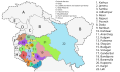 | 1,090 × 652 (155 KB) | फ़िलप्रो | I believe India administers the Siachen Glacier and Demchok region (southeast portion) as part of Leh district | |
| 17:48, 27 July 2017 |  | 1,090 × 652 (178 KB) | RaviC | Added claimed but non-administered districts | |
| 19:51, 12 May 2015 |  | 1,090 × 652 (130 KB) | Furfur | svg aufgeräumt | |
| 18:37, 12 May 2015 | 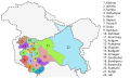 | 1,090 × 652 (221 KB) | Furfur | == {{int:filedesc}} == {{Information |Description={{de|1=Distrikte von Jammu und Kashmir (2015). Achtung: die Karte gibt nur eine grobe Übersicht. Die Distriktgrenzen sind leider nur ungenau, aufgrund mangelhafter zur Verfügung stehender Karten.}}{{e... |
File usage
The following pages on the English Wikipedia use this file (pages on other projects are not listed):
Global file usage
The following other wikis use this file:
- Usage on bh.wikipedia.org
- Usage on bn.wikipedia.org
- Usage on de.wikipedia.org
- Usage on fr.wikipedia.org
- Usage on mr.wikipedia.org
- Usage on sat.wikipedia.org
- Usage on sa.wikipedia.org
- Usage on te.wikipedia.org