
File:Ivy City 1887.jpg

Size of this preview: 660 × 599 pixels. Other resolutions: 264 × 240 pixels | 529 × 480 pixels | 759 × 689 pixels.
Original file (759 × 689 pixels, file size: 218 KB, MIME type: image/jpeg)
| This is a file from the Wikimedia Commons. Information from its description page there is shown below. Commons is a freely licensed media file repository. You can help. |
Summary
| Description |
English: A map of the District of Columbia from 1887, showing the location of Ivy City, the Ivy City Racecourse, and other local points of interest. |
| Date | |
| Source | https://www.dcvote.org/sites/default/files/documents/articles/30_0.pdf |
| Author | Silversparre, Axel. Map of Washington, D.C., and Environs: With marginal numbers and measuring tape attachment for instantly locating points of interest within a radius of twenty miles from the Capitol. Washington, D.C.: R.E. Whitman, 1887. |
Licensing
This media file is in the public domain in the United States. This applies to U.S. works where the copyright has expired, often because its first publication occurred prior to January 1, 1929, and if not then due to lack of notice or renewal. See this page for further explanation.
|
 | |
 |
This image might not be in the public domain outside of the United States; this especially applies in the countries and areas that do not apply the rule of the shorter term for US works, such as Canada, Mainland China (not Hong Kong or Macao), Germany, Mexico, and Switzerland. The creator and year of publication are essential information and must be provided. See Wikipedia:Public domain and Wikipedia:Copyrights for more details.
|
File history
Click on a date/time to view the file as it appeared at that time.
| Date/Time | Thumbnail | Dimensions | User | Comment | |
|---|---|---|---|---|---|
| current | 21:00, 14 August 2015 | 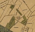 | 759 × 689 (218 KB) | Tim1965 | User created page with UploadWizard |
File usage
The following pages on the English Wikipedia use this file (pages on other projects are not listed):