
File:Iraqi Civil War map (2014–present).svg

Size of this PNG preview of this SVG file: 589 × 600 pixels. Other resolutions: 236 × 240 pixels | 471 × 480 pixels | 754 × 768 pixels | 1,005 × 1,024 pixels | 2,011 × 2,048 pixels | 1,241 × 1,264 pixels.
Original file (SVG file, nominally 1,241 × 1,264 pixels, file size: 775 KB)
| This is a file from the Wikimedia Commons. Information from its description page there is shown below. Commons is a freely licensed media file repository. You can help. |

|
This file may be updated to reflect new information. If you wish to use a specific version of the file without new updates being mirrored, please upload the required version as a separate file. |
Summary
This vector image was created with Inkscape.
| Description |
English: Map of the Iraqi conflict.
In the respective colours: |
||
| Date | (first version) | ||
| Source |
Own work, derived from Template:Iraqi insurgency detailed map and Suriyakmaps
|
||
| Author | Clyde H. Mapping |
Licensing
I, the copyright holder of this work, hereby publish it under the following license:
This file is licensed under the Creative Commons Attribution-Share Alike 4.0 International license.
- You are free:
- to share – to copy, distribute and transmit the work
- to remix – to adapt the work
- Under the following conditions:
- attribution – You must give appropriate credit, provide a link to the license, and indicate if changes were made. You may do so in any reasonable manner, but not in any way that suggests the licensor endorses you or your use.
- share alike – If you remix, transform, or build upon the material, you must distribute your contributions under the same or compatible license as the original.
File history
Click on a date/time to view the file as it appeared at that time.
| Date/Time | Thumbnail | Dimensions | User | Comment | |
|---|---|---|---|---|---|
| current | 15:38, 23 January 2024 | 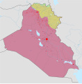 | 1,241 × 1,264 (775 KB) | Clyde H. Mapping | Corrected Kurdistan + Turkish occupation borders |
| 02:12, 4 December 2023 | 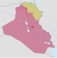 | 1,241 × 1,264 (737 KB) | Clyde H. Mapping | Uploaded own work with UploadWizard |
File usage
The following pages on the English Wikipedia use this file (pages on other projects are not listed):
Global file usage
The following other wikis use this file:
- Usage on fa.wikipedia.org
- Usage on tr.wikipedia.org