
File:India Jammu and Kashmir UT adm relief map.svg

Size of this PNG preview of this SVG file: 612 × 599 pixels. Other resolutions: 245 × 240 pixels | 490 × 480 pixels | 785 × 768 pixels | 1,046 × 1,024 pixels | 2,092 × 2,048 pixels | 757 × 741 pixels.
Original file (SVG file, nominally 757 × 741 pixels, file size: 1.98 MB)
| This is a file from the Wikimedia Commons. Information from its description page there is shown below. Commons is a freely licensed media file repository. You can help. |
Summary
| Description |
English: Relief map of the Union Territory of Jammu and Kashmir. Relief map equivalent of File:India Jammu and Kashmir UT adm location map.svg. This map reflects the de-facto situation only and does not endorse any party's claim in the dispute. |
| Date | |
| Source | Derivative of File:India Jammu and Kashmir UT adm location map.svg |
| Author | Own work based on user:NordNordWest |
Licensing
This file is licensed under the Creative Commons Attribution-Share Alike 3.0 Unported license.
- You are free:
- to share – to copy, distribute and transmit the work
- to remix – to adapt the work
- Under the following conditions:
- attribution – You must give appropriate credit, provide a link to the license, and indicate if changes were made. You may do so in any reasonable manner, but not in any way that suggests the licensor endorses you or your use.
- share alike – If you remix, transform, or build upon the material, you must distribute your contributions under the same or compatible license as the original.
File history
Click on a date/time to view the file as it appeared at that time.
| Date/Time | Thumbnail | Dimensions | User | Comment | |
|---|---|---|---|---|---|
| current | 15:19, 11 July 2022 | 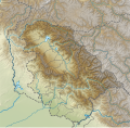 | 757 × 741 (1.98 MB) | C1MM | Uploaded a work by Own work based on user:NordNordWest from Derivative of File:India Jammu and Kashmir UT adm location map.svg with UploadWizard |
File usage
The following pages on the English Wikipedia use this file (pages on other projects are not listed):
- Ahansar Lake
- Amarnath Peak
- Amarnath Temple
- Apharwat Peak
- Avantiswami Temple
- Baglihar Dam
- Banganga River (Jammu and Kashmir)
- Banihal Pass
- Bhimber Gali
- Bijbehara
- Brammah
- Brari Nambal
- Bumzuva Cave and Temple
- Chattergala Pass
- Dachigam National Park
- Dal Lake
- Gadsar Lake
- Gangabal Lake
- Gil Sar
- Gufkral
- Gulmarg Wildlife Sanctuary
- Hari Parbat
- Harmukh
- Jamia Masjid, Shopian
- Jamia Masjid, Srinagar
- Jhangar
- Kalgoni River
- Kalnai River
- Kausar Nag
- Khanpursar
- Khushal Sar
- Kishanganga Hydroelectric Project
- Kolahoi Peak
- Krishansar Lake
- Machoi Glacier
- Machoi Peak
- Mahadev Peak
- Manasbal Lake
- Mansar Lake
- Margan Top
- Marsar Lake
- Meenamarg
- Nandan Sar Lake
- Narayanbagh Lake
- Neeru river
- Nigeen Lake
- Nundkol Lake
- Overa-Aru Wildlife Sanctuary
- Pakal Dul Dam
- Parihaspore
- Pir Panjal Pass
- Poonch (town)
- Ratle Hydroelectric Plant
- Razdan Pass
- Sadhna Pass
- Salal Dam
- Satsar Lake
- Sheshnag Lake
- Sickle Moon Peak
- Sinthan Top
- Sirbal Peak
- Sonbain Ashapati
- Sunset Peak (Jammu and Kashmir)
- Tarsar Lake
- Tatakooti Peak
- Tral
- Tulian lake
- Udhampur
- Vaishno Devi Temple
- Vishansar Lake
- Waskura Lake
- Wular Lake
- Zoji-la Tunnel
- Zoji La
- User:Gārgīyajyotiṣa/sandbox
- User:MBlaze Lightning/Stok Kangri
- User:Ty654/List of earthquakes from 1930-1939 exceeding magnitude 6+
- Module:Location map/data/India Jammu and Kashmir
- Module:Location map/data/India Jammu and Kashmir/doc
- Module:Location map/data/India Jammu and Kashmir/sandbox
- Module:Location map/data/Jammu and Kashmir
- Module:Location map/data/Jammu and Kashmir/doc
Global file usage
The following other wikis use this file:
- Usage on de.wikipedia.org
- Baglihar-Talsperre
- Dal-See
- Ranjit-Sagar-Talsperre
- Kolahoi
- Kolahoigletscher
- Sickle Moon
- Brammah I
- Brammah II
- Haramukh
- Kishtwar Kailash
- Kishtwar Shivling
- Hagshu
- Cerro Kishtwar
- Gadsar Lake
- Konsarnag
- Krishansar Lake
- Gangbal Lake
- Salal-Talsperre
- Dul-Hasti-Talsperre
- Uri-I-Talsperre
- Uri-II-Talsperre
- Lower-Jhelum-Staustufe
- Vorlage:Positionskarte Indien Jammu und Kashmir
- Jawahar-Tunnel
- Pir Panjal Railway Tunnel
- Dr. Syama Prasad Mookerjee Tunnel
- Banihal Qazigund Road Tunnel
- Usage on fr.wikipedia.org
- Usage on hi.wikipedia.org
View more global usage of this file.