
File:Hurricane Gert visible satellite loop.gif

No higher resolution available.
Hurricane_Gert_visible_satellite_loop.gif (266 × 270 pixels, file size: 2.81 MB, MIME type: image/gif, looped, 54 frames, 5.4 s)
| This is a file from the Wikimedia Commons. Information from its description page there is shown below. Commons is a freely licensed media file repository. You can help. |
Summary
| Description |
English: A satellite loop capture from September 18–21 showing Hurricane Gert of 1993 crossing the Gulf, making landfall on the east Mexican coast, and traversing land. |
| Date | |
| Source | http://www.ssd.noaa.gov/goes/east/ |
| Author | NOAA (page is updated every week; its archives hold only up to 4 weeks of information. Hence, the site no longer hosts the animation.) |
Licensing
This image is in the public domain because it contains materials that originally came from the U.S. National Oceanic and Atmospheric Administration, taken or made as part of an employee's official duties.
|
File history
Click on a date/time to view the file as it appeared at that time.
| Date/Time | Thumbnail | Dimensions | User | Comment | |
|---|---|---|---|---|---|
| current | 22:49, 26 October 2017 | 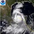 | 266 × 270 (2.81 MB) | Hylian Auree | rm white noise frame |
| 22:39, 26 October 2017 | 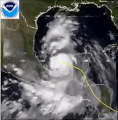 | 266 × 270 (1.31 MB) | Hylian Auree | User created page with UploadWizard |
File usage
The following pages on the English Wikipedia use this file (pages on other projects are not listed):
Global file usage
The following other wikis use this file:
- Usage on pt.wikipedia.org