
File:Hume Lake California Topo.png

Size of this preview: 391 × 600 pixels. Other resolutions: 156 × 240 pixels | 500 × 767 pixels.
Original file (500 × 767 pixels, file size: 250 KB, MIME type: image/png)
| This is a file from the Wikimedia Commons. Information from its description page there is shown below. Commons is a freely licensed media file repository. You can help. |
Summary
| Description | A topographical map of Hume Lake in the Sequoia National Forest in Fresno County, California. |
| Source | [1] |
| Author |
This image is a work of the Forest Service of the United States Department of Agriculture. As a work of the U.S. federal government, the image is in the public domain.
|
File history
Click on a date/time to view the file as it appeared at that time.
| Date/Time | Thumbnail | Dimensions | User | Comment | |
|---|---|---|---|---|---|
| current | 12:46, 26 February 2005 | 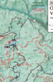 | 500 × 767 (250 KB) | Niteowlneils~commonswiki | {{PD-USGov}}From [http://www.fs.fed.us/r5/sequoia/recreation/ohv-osv/hl/nec.html] |
File usage
The following pages on the English Wikipedia use this file (pages on other projects are not listed):