
File:Historic 18th Century Houses in Bempton High Street.jpg

No higher resolution available.
Historic_18th_Century_Houses_in_Bempton_High_Street.jpg (446 × 306 pixels, file size: 21 KB, MIME type: image/jpeg)
| This is a file from the Wikimedia Commons. Information from its description page there is shown below. Commons is a freely licensed media file repository. You can help. |
Summary
| Description |
English: Historic 18th Century Houses in the High Street, Bempton, East Riding of Yorkshire, England. These houses are probably the oldest houses in Bempton, located opposite the Parish Church in the centre of the village. In 1851 the road in front did not exist. Agricultural workers lived in these cottages some of which have original wooden beams. There were many dairy farms in Bempton. The RSPB Reserve at Bempton Cliffs is nearby. These are the highest Cliffs on the East Coast of England. Danes Dyke Earthwork reputed to be bronze age or earlier separates Bempton from Flamborough. |
| Date | |
| Source | From geograph.org.uk |
| Author | david hinde |
| Permission (Reusing this file) |
Creative Commons Attribution Share-alike license 2.0 |
| Object location | | View this and other nearby images on: OpenStreetMap |
|---|
Licensing

|
This image was taken from the Geograph project collection. See this photograph's page on the Geograph website for the photographer's contact details. The copyright on this image is owned by david hinde and is licensed for reuse under the Creative Commons Attribution-ShareAlike 2.0 license.
|
This file is licensed under the Creative Commons Attribution-Share Alike 2.0 Generic license.
Attribution: david hinde
- You are free:
- to share – to copy, distribute and transmit the work
- to remix – to adapt the work
- Under the following conditions:
- attribution – You must give appropriate credit, provide a link to the license, and indicate if changes were made. You may do so in any reasonable manner, but not in any way that suggests the licensor endorses you or your use.
- share alike – If you remix, transform, or build upon the material, you must distribute your contributions under the same or compatible license as the original.
File history
Click on a date/time to view the file as it appeared at that time.
| Date/Time | Thumbnail | Dimensions | User | Comment | |
|---|---|---|---|---|---|
| current | 21:20, 18 June 2011 | 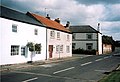 | 446 × 306 (21 KB) | Cropbot | upload cropped version, operated by User:Finavon. Summary: border cropped |
| 16:36, 13 October 2007 |  | 446 × 322 (23 KB) | Angusmclellan | {{Information |Description=Historic 18th Century Houses in the High Street, Bempton, East Riding of Yorkshire |Source=Geograph project http://www.geograph.org.uk/photo/165727 |Date=Thursday, 23 June, 2005 | |
File usage
The following pages on the English Wikipedia use this file (pages on other projects are not listed):