
File:Hillsgrove Covered Bridge composite.png

Size of this preview: 442 × 599 pixels. Other resolutions: 177 × 240 pixels | 354 × 480 pixels | 566 × 768 pixels | 755 × 1,024 pixels | 1,510 × 2,048 pixels | 2,808 × 3,808 pixels.
Original file (2,808 × 3,808 pixels, file size: 25.2 MB, MIME type: image/png)
| This is a file from the Wikimedia Commons. Information from its description page there is shown below. Commons is a freely licensed media file repository. You can help. |
Summary
| Description |
English: Hillsgrove Covered Bridge over Loyalsock Creek in Hillsgrove Township, Sullivan County, Pennsylvania in the United States, as seen in 2012 after restoration (top), 2011 after flood damage (middle), and 2008 (bottom). |
| Date | |
| Source | Own work by uploader, see other versions for the three sources |
| Author | Ruhrfisch |
| Permission (Reusing this file) |
GFDL |
| Other versions |
   |
|
This is an image of a place or building that is listed on the National Register of Historic Places in the United States of America. Its reference number is 73001666. |
| Camera location | | View this and other nearby images on: OpenStreetMap |
|---|
Licensing
I, the copyright holder of this work, hereby publish it under the following licenses:

|
Permission is granted to copy, distribute and/or modify this document under the terms of the GNU Free Documentation License, Version 1.2 or any later version published by the Free Software Foundation; with no Invariant Sections, no Front-Cover Texts, and no Back-Cover Texts. A copy of the license is included in the section entitled GNU Free Documentation License. |
This file is licensed under the Creative Commons Attribution-Share Alike 4.0 International, 3.0 Unported, 2.5 Generic, 2.0 Generic and 1.0 Generic license.
- You are free:
- to share – to copy, distribute and transmit the work
- to remix – to adapt the work
- Under the following conditions:
- attribution – You must give appropriate credit, provide a link to the license, and indicate if changes were made. You may do so in any reasonable manner, but not in any way that suggests the licensor endorses you or your use.
- share alike – If you remix, transform, or build upon the material, you must distribute your contributions under the same or compatible license as the original.
You may select the license of your choice.
File history
Click on a date/time to view the file as it appeared at that time.
| Date/Time | Thumbnail | Dimensions | User | Comment | |
|---|---|---|---|---|---|
| current | 13:08, 3 January 2015 | 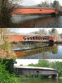 | 2,808 × 3,808 (25.2 MB) | Ruhrfisch | Better stitch of the top photo, cropped composite slightly (not quite as tall), otherwise the same |
| 02:16, 3 January 2015 |  | 2,808 × 3,952 (26.14 MB) | Ruhrfisch | {{Information |Description={{en|1=Hillsgrove Covered Bridge over Loyalsock Creek in Hillsgrove Township, Sullivan County, Pennsylvania in the United States, as seen in 2012 after restoration (top), 2011 after flood damage (middle), and 2008 (bottom). }... |
File usage
The following pages on the English Wikipedia use this file (pages on other projects are not listed):
Global file usage
The following other wikis use this file:
- Usage on ms.wikipedia.org
- Usage on tr.wikipedia.org
- Usage on vi.wikipedia.org