
File:Higos 2015 rapid deepening RBTOP.gif

No higher resolution available.
Higos_2015_rapid_deepening_RBTOP.gif (720 × 480 pixels, file size: 2.26 MB, MIME type: image/gif, looped, 15 frames, 3.1 s)
| This is a file from the Wikimedia Commons. Information from its description page there is shown below. Commons is a freely licensed media file repository. You can help. |
Summary
| Description |
English: The infrared MTSAT-2 satellite loop with RBTOP enhancements presents Typhoon Higos in 2015 undergoing rapid intensification, from 23:01 UTC on February 9 to 05:32 UTC on February 10. It was the most intense February tropical cyclone of the Northern Hemisphere since reliable records. |
| Date | |
| Source | http://www.ssd.noaa.gov/PS/TROP/floaters/ |
| Author | National Oceanic and Atmospheric Administration Satellite Services Division |
| Other versions |
|

Licensing
This image is in the public domain because it contains materials that originally came from the U.S. National Oceanic and Atmospheric Administration, taken or made as part of an employee's official duties.
|
File history
Click on a date/time to view the file as it appeared at that time.
| Date/Time | Thumbnail | Dimensions | User | Comment | |
|---|---|---|---|---|---|
| current | 12:08, 10 February 2015 | 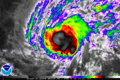 | 720 × 480 (2.26 MB) | Meow | User created page with UploadWizard |
File usage
The following pages on the English Wikipedia use this file (pages on other projects are not listed):
Global file usage
The following other wikis use this file:
- Usage on ko.wikipedia.org
- Usage on zh.wikipedia.org