
File:Harleyford Road - geograph.org.uk - 1013044.jpg

No higher resolution available.
Harleyford_Road_-_geograph.org.uk_-_1013044.jpg (640 × 480 pixels, file size: 82 KB, MIME type: image/jpeg)
| This is a file from the Wikimedia Commons. Information from its description page there is shown below. Commons is a freely licensed media file repository. You can help. |
Summary
| Description |
English: Harleyford Road. This is the west end with the lowest numbers, namely in their 20s as the street has been shortened due to the large Vauxhall Cross gyratory behind the camera. Cobalt Square is the large footprint building on the right. Traffic approaches only as viewed (is westbound only here); the east end is however a two-way street. |
| Date | |
| Source | From geograph.org.uk |
| Author | Oxyman |
| Attribution (required by the license) | Oxyman / Harleyford Road / |
| Camera location | | View this and other nearby images on: OpenStreetMap |
|---|
| Object location | | View this and other nearby images on: OpenStreetMap |
|---|
Licensing

|
This image was taken from the Geograph project collection. See this photograph's page on the Geograph website for the photographer's contact details. The copyright on this image is owned by Oxyman and is licensed for reuse under the Creative Commons Attribution-ShareAlike 2.0 license.
|
This file is licensed under the Creative Commons Attribution-Share Alike 2.0 Generic license.
Attribution: Oxyman
- You are free:
- to share – to copy, distribute and transmit the work
- to remix – to adapt the work
- Under the following conditions:
- attribution – You must give appropriate credit, provide a link to the license, and indicate if changes were made. You may do so in any reasonable manner, but not in any way that suggests the licensor endorses you or your use.
- share alike – If you remix, transform, or build upon the material, you must distribute your contributions under the same or compatible license as the original.
File history
Click on a date/time to view the file as it appeared at that time.
| Date/Time | Thumbnail | Dimensions | User | Comment | |
|---|---|---|---|---|---|
| current | 10:56, 23 February 2011 | 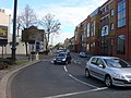 | 640 × 480 (82 KB) | GeographBot | == {{int:filedesc}} == {{Information |description={{en|1=Harleyford Road}} |date=2008-10-18 |source=From [http://www.geograph.org.uk/photo/1013044 geograph.org.uk] |author=[http://www.geograph.org.uk/profile/13090 Oxyman] |permission= |other_versions= }} |
File usage
The following pages on the English Wikipedia use this file (pages on other projects are not listed):