
File:Grand Portage route.JPG
No higher resolution available.
Grand_Portage_route.JPG (629 × 561 pixels, file size: 74 KB, MIME type: image/jpeg)
| This is a file from the Wikimedia Commons. Information from its description page there is shown below. Commons is a freely licensed media file repository. You can help. |
Summary
| Description |
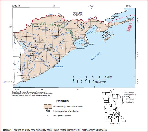
English: Grand Portage National Monument, Minnesota, map, in Northeastern Minnesota; prepared by the Minnesota Geological Survey and used by the USGS in, "Ground-Water/Surface-Water Interaction in Nearshore Areas of Three Lakes on the Grand Portage Reservation, Northeastern Minnesota, 2003-04" |
||
| Date | |||
| Source | USGS (citing Minnesota Geological Survey): Scientific Investigations Report 2006–5034 http://pubs.usgs.gov/sir/2006/5034/pdf/SIR20065034.pdf | ||
| Author | Miller, J.D. Jr., Green, J.C., Severson, M.J., Chandler, W.V., Hauck, S.A., Peterson, D.M., and Wahl, T.E. Cited in report by Perry M. Jones. | ||
| Other versions |
|


Licensing
This image is in the public domain in the United States because it only contains materials that originally came from the United States Geological Survey, an agency of the United States Department of the Interior. For more information, see the official USGS copyright policy.
|
Original upload log
The original description page was here. All following user names refer to en.wikipedia.
| Date/Time | Dimensions | User | Comment |
|---|---|---|---|
| 2010-03-05 23:35 | 629×561× (75472 bytes) | Bettymnz4 | {{Information |Description ="""English:'''Grand Portage National Monument, Minnesota, map, in Northeastern Minnesota; prepared by the Minnesota Geological Survey and used by the USGS in, "Ground-Water/Surface-Water Interaction in Nearshore Areas of Th |
File history
Click on a date/time to view the file as it appeared at that time.
| Date/Time | Thumbnail | Dimensions | User | Comment | |
|---|---|---|---|---|---|
| current | 04:19, 17 August 2015 |  | 629 × 561 (74 KB) | Innotata | Transferred from en.wikipedia |
File usage
The following pages on the English Wikipedia use this file (pages on other projects are not listed):
Global file usage
The following other wikis use this file:
- Usage on ru.wikipedia.org