
File:Grand Central Post Office 1988.jpg

Size of this preview: 739 × 600 pixels. Other resolutions: 296 × 240 pixels | 592 × 480 pixels | 947 × 768 pixels | 1,262 × 1,024 pixels | 2,524 × 2,048 pixels | 4,459 × 3,618 pixels.
Original file (4,459 × 3,618 pixels, file size: 7.46 MB, MIME type: image/jpeg)
| This is a file from the Wikimedia Commons. Information from its description page there is shown below. Commons is a freely licensed media file repository. You can help. |
Summary
| NORTH AND EAST ELEVATIONS, LOOKING SOUTHWEST - Grand Central Post Office Annex, Forty-fifth Street and Lexington Avenue, Southwest corner, New York, New York County, NY | ||||
|---|---|---|---|---|
| Title |
NORTH AND EAST ELEVATIONS, LOOKING SOUTHWEST - Grand Central Post Office Annex, Forty-fifth Street and Lexington Avenue, Southwest corner, New York, New York County, NY |
|||
| Depicted place | New York; New York County; New York | |||
| Date | November 1988 | |||
| Dimensions | 4 x 5 in. | |||
| Current location |
Library of Congress Prints and Photographs Division Washington, D.C. 20540 USA http://hdl.loc.gov/loc.pnp/pp.print |
|||
| Accession number |
HABS NY,31-NEYO,169-1 |
|||
| Credit line |
|
|||
| Source | https://www.loc.gov/pictures/item/ny1617.photos.119248p | |||
| Permission (Reusing this file) |
|
|||
| Other versions | File:NORTH AND EAST ELEVATIONS, LOOKING SOUTHWEST - Grand Central Post Office Annex, Forty-fifth Street and Lexington Avenue, Southwest corner, New York, New York County, NY HABS NY,31-NEYO,169-1.tif | |||

File history
Click on a date/time to view the file as it appeared at that time.
| Date/Time | Thumbnail | Dimensions | User | Comment | |
|---|---|---|---|---|---|
| current | 00:48, 19 September 2020 | 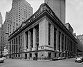 | 4,459 × 3,618 (7.46 MB) | Ɱ | Uploaded own work with UploadWizard |
File usage
The following pages on the English Wikipedia use this file (pages on other projects are not listed):
Global file usage
The following other wikis use this file:
- Usage on de.wikipedia.org