
File:Gotland-Bro-kyrka 01.jpg

Size of this preview: 450 × 600 pixels. Other resolutions: 180 × 240 pixels | 360 × 480 pixels | 960 × 1,280 pixels.
Original file (960 × 1,280 pixels, file size: 291 KB, MIME type: image/jpeg)
| This is a file from the Wikimedia Commons. Information from its description page there is shown below. Commons is a freely licensed media file repository. You can help. |
| Camera location | | View this and other nearby images on: OpenStreetMap |
|---|
|
This is a photo of a protected building in Sweden, number 21300000002620 in the RAÄ buildings database.
|
| Description |
Deutsch: Bro kyrka (Gotland). Turm aus dem späten 12.Jh. Chor von 1236, Langhaus von 1300 |
| Date | |
| Source | Self-photographed |
| Author | Jürgen Howaldt |
This file is licensed under the Creative Commons Attribution-Share Alike 2.0 Germany license.
- You are free:
- to share – to copy, distribute and transmit the work
- to remix – to adapt the work
- Under the following conditions:
- attribution – You must give appropriate credit, provide a link to the license, and indicate if changes were made. You may do so in any reasonable manner, but not in any way that suggests the licensor endorses you or your use.
- share alike – If you remix, transform, or build upon the material, you must distribute your contributions under the same or compatible license as the original.

File history
Click on a date/time to view the file as it appeared at that time.
| Date/Time | Thumbnail | Dimensions | User | Comment | |
|---|---|---|---|---|---|
| current | 13:41, 12 September 2005 | 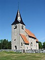 | 960 × 1,280 (291 KB) | Godewind | {{Bildbeschreibung| Bro kyrka (Gotland). |selbst erstelltes Foto | Jürgen Howaldt |13.07.2005 |- }} {{Bild-CC-by-sa/2.0/de}} Category:Bro kyrka, Gotland |
File usage
The following pages on the English Wikipedia use this file (pages on other projects are not listed):
Global file usage
The following other wikis use this file:
- Usage on de.wikipedia.org
- Usage on fi.wikipedia.org
- Usage on nl.wikipedia.org
- Usage on sv.wikipedia.org
- Wikipedia:Projekt kyrkobyggnader
- Mall:Projekt kyrkobyggnader
- Bro, Gotlands kommun
- Kategori:Kyrkobyggnader i Lunds stift
- Kategori:Kyrkobyggnader i Linköpings stift
- Kategori:Kyrkobyggnader i Göteborgs stift
- Kategori:Kyrkobyggnader i Stockholms stift
- Kategori:Kyrkobyggnader i Visby stift
- Kategori:Kyrkobyggnader i Västerås stift
- Kategori:Kyrkobyggnader i Strängnäs stift
- Kategori:Kyrkobyggnader i Luleå stift
- Kategori:Kyrkobyggnader i Uppsala stift
- Kategori:Kyrkobyggnader i Skara stift
- Kategori:Kyrkobyggnader i Växjö stift
- Kategori:Kyrkobyggnader i Karlstads stift
- Kategori:Kyrkobyggnader i Härnösands stift
- Portal:Kyrkor
- Bro församling, Visby stift
- Bro kyrka, Gotland
- Kategori:Kyrkobyggnader i Sverige
- Lista över kyrkliga kulturminnen i Gotlands län
- Usage on www.wikidata.org