
File:Glenmayne House - geograph.org.uk - 696729.jpg

No higher resolution available.
Glenmayne_House_-_geograph.org.uk_-_696729.jpg (640 × 480 pixels, file size: 137 KB, MIME type: image/jpeg)
| This is a file from the Wikimedia Commons. Information from its description page there is shown below. Commons is a freely licensed media file repository. You can help. |
|
This is a photo of listed building number 12929. |
Summary
| Description |
English: Glenmayne House A large Baronial house on an elevated site overlooking the River Tweed. Built in 1866 for John Murray, a wool merchant and pelt-monger. (Source: Borders and Berwick, An Architectural Guide by Charles Alexander Strang).
Viewed in February from a hillside on the opposite side of the River Tweed. The hill in the far background is Meigle Hill. |
| Date | |
| Source | From geograph.org.uk |
| Author | Walter Baxter |
| Attribution (required by the license) | Walter Baxter / Glenmayne House / |
| Camera location | | View this and other nearby images on: OpenStreetMap |
|---|
| Object location | | View this and other nearby images on: OpenStreetMap |
|---|
Licensing

|
This image was taken from the Geograph project collection. See this photograph's page on the Geograph website for the photographer's contact details. The copyright on this image is owned by Walter Baxter and is licensed for reuse under the Creative Commons Attribution-ShareAlike 2.0 license.
|
This file is licensed under the Creative Commons Attribution-Share Alike 2.0 Generic license.
Attribution: Walter Baxter
- You are free:
- to share – to copy, distribute and transmit the work
- to remix – to adapt the work
- Under the following conditions:
- attribution – You must give appropriate credit, provide a link to the license, and indicate if changes were made. You may do so in any reasonable manner, but not in any way that suggests the licensor endorses you or your use.
- share alike – If you remix, transform, or build upon the material, you must distribute your contributions under the same or compatible license as the original.
File history
Click on a date/time to view the file as it appeared at that time.
| Date/Time | Thumbnail | Dimensions | User | Comment | |
|---|---|---|---|---|---|
| current | 05:03, 8 February 2011 | 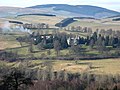 | 640 × 480 (137 KB) | GeographBot | == {{int:filedesc}} == {{Information |description={{en|1=Glenmayne House A large Baronial house on an elevated site overlooking the River Tweed. Built in 1866 for John Murray, a wool merchant and pelt-monger. (Source: Borders and Berwick, An Architectural |
File usage
The following pages on the English Wikipedia use this file (pages on other projects are not listed):
Global file usage
The following other wikis use this file:
- Usage on de.wikipedia.org
- Usage on www.wikidata.org