File:General Map of Switzerland.jpg

This is a file from the Wikimedia Commons
From Wikipedia, the free encyclopedia

Original file(17,280 × 12,412 pixels, file size: 66.78 MB, MIME type: image/jpeg)

Summary

Warning The original file is very high-resolution. It might not load properly or could cause your browser to freeze when opened at full size.
Title
English: General Map of Switzerland
Description
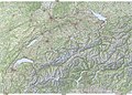
English: Electronic version of the General Map of Switzerland (1:300'000) published by the Federal Office of Topography (swisstopo). Made with four compressed and reduced digital maps (1:200'000) stitched together for a high amount of detail. Scale is 22.22 metres per pixel. Nota bene: The full version map can be consulted more conveniently on the geographical portal.
Map legend
English: Lines of the Swiss grid are 10 km apart. Elevations are in metres and the contour interval is 100 metres. For symbols and notes, see Conventional signs for Swiss National Maps (pp. 8–9, 12), displayed below.
Date
Source
Creator
institution QS:P195,Q685592
 Geotemporal data
Map location Switzerland
Spatial reference system Swiss coordinate system (CH1903+/MN95)
Scale 1:300,000
Heading
Bounding box
N: 48.0308554°N
W: 5.6024039°E E: 10.7465404°E
S: 45.5028181°N
Georeferencing View the georeferenced map in the Wikimaps Warper
 Bibliographic data
Publisher
institution QS:P195,Q685592
Other versions
Object location46° 47′ 54.82″ N, 8° 13′ 55.1″ E Kartographer map based on OpenStreetMap.View this and other nearby images on: OpenStreetMapinfo

Featured picture

Wikimedia Commons

This is a featured picture on Wikimedia Commons (Featured pictures) and is considered one of the finest images. See its nomination here.

If you have an image of similar quality that can be published under a suitable copyright license, be sure to upload it, tag it, and nominate it.

Licensing

The data made publicly available by swisstopo may be used, distributed and made accessible. Furthermore, they may be enriched and processed and also used commercially.

A reference to the source is mandatory. In the case of digital or analogue representations and publications, as well as in the case of dissemination, one of the following source references must be attached in any case:

  • Federal Office of Topography swisstopo
  • Bundesamt für Landestopografie swisstopo
  • Office fédéral de topographie swisstopo
  • Ufficio federale di topografia swisstopo
  • Uffizi federal da topografia swisstopo
  • ©swisstopo

Terms of use for free geodata and geoservices (OGD) from swisstopo
Frequently asked questions about free basic geodata


Deutsch | français | italiano | English | +/−

Captions

General Map of Switzerland

46°47'54.823"N, 8°13'55.103"E

image/jpeg

File history

Click on a date/time to view the file as it appeared at that time.

Date/TimeThumbnailDimensionsUserComment
current13:41, 20 March 2021Thumbnail for version as of 13:41, 20 March 202117,280 × 12,412 (66.78 MB)Zacharie GrossenUploaded a work by Bundesamt für Landestopografie swisstopo from [https://www.swisstopo.admin.ch/en/geodata/maps/smr/smr25.html swisstopo] with UploadWizard

Global file usage