
File:Gele trilzwam (Tremella mesenterica) op dode tak van een eik 15-01-2021. (actm.) 02.jpg

Original file (4,320 × 3,456 pixels, file size: 10.85 MB, MIME type: image/jpeg)
| This is a file from the Wikimedia Commons. Information from its description page there is shown below. Commons is a freely licensed media file repository. You can help. |
Summary
| Description |
Nederlands: Gele trilzwam (Tremella mesenterica) op een dode tak. Focus stapel van 21 foto’s.
English: Yellow fungus (Tremela mesenterica) on dead branch. Focus stack of 21 photos.
Español: Hongo temblón amarillo (Tremella mesenterica) en una rama muerta. Apilamiento de enfoque de 21 fotos.
Français : Champignon jaune d'or appelé "Beurre de Sorcière", Tremela mesenterica, sur une branche morte.
Українська: Гриб тремела звивиста (Tremella mesenterica) на мертвій гілці. Набір фокусів із 21 фотографії. |
| Date | |
| Source | Own work |
| Author | Agnes Monkelbaan |
| Other versions |
|

| Camera location | | View this and other nearby images on: OpenStreetMap |
|---|

|
NOTE: This image is a focus stacked image consisting of multiple images that were merged using software. As a result, this image underwent digital manipulation which may have included blending, blurring, cloning, and colour and perspective adjustments. As a result of these adjustments, the image content may be slightly different than reality at the points where the images were combined. This manipulation is often required due to lens, perspective, and parallax distortions.
|
Locatie: Natuurterrein De Famberhorst is een belangrijke schakel in de ecologische verbinding (groene as) tussen het Friese merengebied, natuurgebied De Twigen, historische windsingel Omkromte, het natuurterrein De Famberhorst en park Heremastate in Joure.
English: Location: The Famberhorst nature reserve is an important link in the ecological connection (green axis) between the Frisian lakes, the historic windbreak Omkromte, the nature reserve and park The Famberhorst Heremastate in Joure.
Assessment
|
This image was selected as picture of the day on Wikimedia Commons for 22 January 2024. It was captioned as follows: English: Yellow fungus (Tremella mesenterica) on dead branch. Focus stack of 21 photos. Other languages:
Čeština: Dřevokazná houba rosolovka mozkovitá (Tremella mesenterica) na odumřelé větvi. Uvedený snímek vznikl počítačovým složením celkem 21 záběrů. Deutsch: Goldgelber Zitterling (Tremella mesenterica) auf einem toten Ast English: Yellow fungus (Tremella mesenterica) on dead branch. Focus stack of 21 photos. Español: Hongo temblón amarillo (Tremella mesenterica) en una rama muerta. Apilamiento de enfoque de 21 fotos. Français : Une trémelle mésentérique (Tremella mesenterica) photographiée aux Pays-Bas. Espèce de champignon saprophyte, elle pousse sur le bois des arbres coupés et des branches mortes. Magyar: Aranyos rezgőgomba (Tremella mesenterica) egy elhalt ágon. 21 felvétel segítségével, fókuszsorozat technikával készült kép Nederlands: Gele trilzwam (Tremella mesenterica) op dode tak Português: Fungo-gelatinoso-dourado (Tremella mesenterica) em um galho morto. Técnica do empilhamento de foco (focus stacking) de 21 imagens. Slovenščina: Rumena drhtavka (Tremella mesenterica) na mrtvi veji. Ostritveni sklad 21 fotografij. Македонски: Желатинска габа (Tremella mesenterica) на исушено гранче. Українська: Гриб тремела звивиста (Tremella mesenterica) на мертвій гілці. Набір фокусів із 21 фотографії. |
This image has been assessed using the Quality image guidelines and is considered a Quality image.
|
Licensing
- You are free:
- to share – to copy, distribute and transmit the work
- to remix – to adapt the work
- Under the following conditions:
- attribution – You must give appropriate credit, provide a link to the license, and indicate if changes were made. You may do so in any reasonable manner, but not in any way that suggests the licensor endorses you or your use.
- share alike – If you remix, transform, or build upon the material, you must distribute your contributions under the same or compatible license as the original.
File history
Click on a date/time to view the file as it appeared at that time.
| Date/Time | Thumbnail | Dimensions | User | Comment | |
|---|---|---|---|---|---|
| current | 16:32, 5 February 2022 | 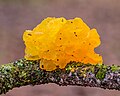 | 4,320 × 3,456 (10.85 MB) | Agnes Monkelbaan | Kleine correctie. |
| 16:58, 6 February 2021 | 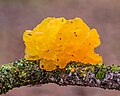 | 4,320 × 3,456 (9.79 MB) | Agnes Monkelbaan | Uploaded own work with UploadWizard |
File usage
Global file usage
The following other wikis use this file:
- Usage on av.wikipedia.org
- Usage on cv.wikipedia.org
- Usage on da.wikipedia.org
- Usage on et.wikipedia.org
- Usage on fr.wikipedia.org
- Usage on hu.wikipedia.org
- Usage on it.wiktionary.org
- Usage on ka.wikipedia.org
- Usage on ko.wikipedia.org
- Usage on lez.wikipedia.org
- Usage on mk.wikipedia.org
- Usage on myv.wikipedia.org
- Usage on nl.wikipedia.org
- Usage on os.wikipedia.org
- Usage on pt.wikipedia.org
- Usage on ru.wikipedia.org
- Usage on sah.wikipedia.org
- Usage on uk.wikipedia.org
- Usage on uz.wikipedia.org
- Usage on vep.wikipedia.org
- Usage on zh.wikipedia.org