
File:Garibaldi Lake area map.jpg

No higher resolution available.
Garibaldi_Lake_area_map.jpg (574 × 468 pixels, file size: 81 KB, MIME type: image/jpeg)
| This is a file from the Wikimedia Commons. Information from its description page there is shown below. Commons is a freely licensed media file repository. You can help. |
Summary
| Description |
English: Map of volcanic features around Garibaldi Lake. |
| Date | |
| Source | NASA World Wind |
| Author | NASA/Black Tusk |
| Permission (Reusing this file) |
NASA, public domian |
Licensing
| This image is in the public domain because it is a screenshot from NASA’s globe software World Wind using a public domain layer, such as Blue Marble, MODIS, Landsat, SRTM, USGS or GLOBE.
|
 |
File history
Click on a date/time to view the file as it appeared at that time.
| Date/Time | Thumbnail | Dimensions | User | Comment | |
|---|---|---|---|---|---|
| current | 15:38, 13 November 2012 | 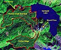 | 574 × 468 (81 KB) | Black Tusk | make image smaller |
| 18:04, 28 September 2008 | 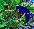 | 659 × 548 (112 KB) | Black Tusk | {{Information |Description={{en|1=Map of volcanic features around Garibaldi Lake.}} |Source=NASA World Wind |Author=NASA/Black Tusk |Date=September 28, 2008 |Permission=NASA, public domian |other_versions= }} <!--{{ImageUpload|ful |
File usage
The following pages on the English Wikipedia use this file (pages on other projects are not listed):
Global file usage
The following other wikis use this file:
- Usage on ar.wikipedia.org
- Usage on fr.wikipedia.org
- Usage on ja.wikipedia.org