
File:Gaeltacht Park, Whitehall. Dublin, Ireland - geograph.org.uk - 332084.jpg

No higher resolution available.
Gaeltacht_Park,_Whitehall._Dublin,_Ireland_-_geograph.org.uk_-_332084.jpg (640 × 427 pixels, file size: 128 KB, MIME type: image/jpeg)
| This is a file from the Wikimedia Commons. Information from its description page there is shown below. Commons is a freely licensed media file repository. You can help. |
Summary
| Description |
English: Gaeltacht Park, Whitehall. Dublin, Ireland This estate was originally built solely for Irish speakers in 1924, hence Gaeltacht which means Irish speaking area in Irish. It was expanded to incorporate the housing needs of members of other Public Utility Societies such as the Post Office and the Civil Service. |
| Date | |
| Source | From geograph.org.uk |
| Author | Peter Gerken |
| Attribution (required by the license) | Peter Gerken / Gaeltacht Park, Whitehall. Dublin, Ireland / |
| Camera location | | View this and other nearby images on: OpenStreetMap |
|---|
| Object location | | View this and other nearby images on: OpenStreetMap |
|---|
Licensing

|
This image was taken from the Geograph project collection. See this photograph's page on the Geograph website for the photographer's contact details. The copyright on this image is owned by Peter Gerken and is licensed for reuse under the Creative Commons Attribution-ShareAlike 2.0 license.
|
This file is licensed under the Creative Commons Attribution-Share Alike 2.0 Generic license.
Attribution: Peter Gerken
- You are free:
- to share – to copy, distribute and transmit the work
- to remix – to adapt the work
- Under the following conditions:
- attribution – You must give appropriate credit, provide a link to the license, and indicate if changes were made. You may do so in any reasonable manner, but not in any way that suggests the licensor endorses you or your use.
- share alike – If you remix, transform, or build upon the material, you must distribute your contributions under the same or compatible license as the original.
File history
Click on a date/time to view the file as it appeared at that time.
| Date/Time | Thumbnail | Dimensions | User | Comment | |
|---|---|---|---|---|---|
| current | 21:48, 30 December 2010 | 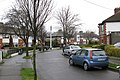 | 640 × 427 (128 KB) | GeographBot | == {{int:filedesc}} == {{Information |description={{en|1=Gaeltacht Park, Whitehall. Dublin, Ireland This estate was originally built solely for Irish speakers in 1924, hence Gaeltacht which means Irish speaking area in Irish. It was expanded to incorporat |
File usage
The following pages on the English Wikipedia use this file (pages on other projects are not listed):
Global file usage
The following other wikis use this file:
- Usage on eu.wikipedia.org
- Usage on www.wikidata.org