
File:GCR & Met Railways 1906.svg
Size of this PNG preview of this SVG file: 334 × 493 pixels. Other resolutions: 162 × 240 pixels | 325 × 480 pixels | 520 × 768 pixels | 694 × 1,024 pixels | 1,387 × 2,048 pixels.
Original file (SVG file, nominally 334 × 493 pixels, file size: 24 KB)
| This is a file from the Wikimedia Commons. Information from its description page there is shown below. Commons is a freely licensed media file repository. You can help. |
Summary
| Description |
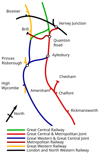
English: In 1906 the Great Central Railway had two routes to London, either by the Metropolitan Railway via Amersham or the Great Central and Great Western Joint Railway via High Wycombe. |
| Date | |
| Source |
Own work Information from Using File:Aylesbury, High Wycombe, Princes Risboro, Quainton Road & Verney Ashendon RJD 146.jpg as likely to be more accurate. |
| Author | Edgepedia |
Licensing
I, the copyright holder of this work, hereby publish it under the following license:
This file is licensed under the Creative Commons Attribution-Share Alike 3.0 Unported license.
- You are free:
- to share – to copy, distribute and transmit the work
- to remix – to adapt the work
- Under the following conditions:
- attribution – You must give appropriate credit, provide a link to the license, and indicate if changes were made. You may do so in any reasonable manner, but not in any way that suggests the licensor endorses you or your use.
- share alike – If you remix, transform, or build upon the material, you must distribute your contributions under the same or compatible license as the original.
File history
Click on a date/time to view the file as it appeared at that time.
| Date/Time | Thumbnail | Dimensions | User | Comment | |
|---|---|---|---|---|---|
| current | 20:25, 2 July 2012 |  | 334 × 493 (24 KB) | Edgepedia | Same and valid fonts through, maintain aspect ratio to minimise white space by adding compass however continue use clearing house maps as source. |
| 18:52, 9 June 2012 |  | 467 × 366 (20 KB) | DavidCane | Rotate so that north is at the top; adjust colours; add missing branches for context; correct line ownership based on railway clearing house diagram; identify all railways | |
| 06:57, 20 May 2012 |  | 319 × 450 (21 KB) | Edgepedia | Fix spelling, font, change colours for clearer distinsion | |
| 07:20, 19 May 2012 |  | 322 × 460 (22 KB) | Edgepedia | Add key, change colours, show GW&GCR and GCR differently | |
| 21:06, 18 May 2012 | 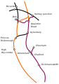 | 322 × 460 (19 KB) | Edgepedia | Fix | |
| 20:42, 18 May 2012 | 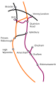 | 309 × 469 (19 KB) | Edgepedia | Fix | |
| 20:17, 18 May 2012 |  | 309 × 469 (21 KB) | Edgepedia | Correct | |
| 19:26, 18 May 2012 | 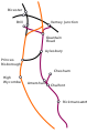 | 309 × 469 (21 KB) | Edgepedia |
File usage
The following pages on the English Wikipedia use this file (pages on other projects are not listed):
Global file usage
The following other wikis use this file:
- Usage on da.wikipedia.org
- Usage on de.wikipedia.org
- Usage on es.wikipedia.org
- Usage on ja.wikipedia.org