
File:Fraser Down - geograph.org.uk - 1351677.jpg

No higher resolution available.
Fraser_Down_-_geograph.org.uk_-_1351677.jpg (640 × 426 pixels, file size: 114 KB, MIME type: image/jpeg)
| This is a file from the Wikimedia Commons. Information from its description page there is shown below. Commons is a freely licensed media file repository. You can help. |
Summary
| Description |
English: Fraser Down Fraser Down was purchased by Surrey Wildlife Trust in 2008 after many years of negotiation with its owners. Although largely overrun with scrub, it has great potential as a link between the existing SWT reserve of Dawcombe, on the other side of the B2032 Pebblehill Road, and the former Betchworth Quarry, also managed by the SWT with the view to converting a landfilled quarry to downland. By restoring areas of the new reserve to open grassland, the aim is to provide stepping stones for chalkland specialists, such as the Silver Spotted Skipper butterfly, to move between sites, rather than being restricted to isolated pockets.
This photo was taken on a recorders evening, when the SWT invited members of the Surrey Botanical Society and other bodies to help build up a picture of the flora and fauna already on the site. It shows part of the upper section of the reserve, in an area less affected by scrub than the rest of the site. In the background is the existing SWT reserve of Dawcombe. |
| Date | |
| Source | From geograph.org.uk |
| Author | Ian Capper |
| Attribution (required by the license) | Ian Capper / Fraser Down / |
| Camera location | | View this and other nearby images on: OpenStreetMap |
|---|
| Object location | | View this and other nearby images on: OpenStreetMap |
|---|
Licensing

|
This image was taken from the Geograph project collection. See this photograph's page on the Geograph website for the photographer's contact details. The copyright on this image is owned by Ian Capper and is licensed for reuse under the Creative Commons Attribution-ShareAlike 2.0 license.
|
This file is licensed under the Creative Commons Attribution-Share Alike 2.0 Generic license.
Attribution: Ian Capper
- You are free:
- to share – to copy, distribute and transmit the work
- to remix – to adapt the work
- Under the following conditions:
- attribution – You must give appropriate credit, provide a link to the license, and indicate if changes were made. You may do so in any reasonable manner, but not in any way that suggests the licensor endorses you or your use.
- share alike – If you remix, transform, or build upon the material, you must distribute your contributions under the same or compatible license as the original.
File history
Click on a date/time to view the file as it appeared at that time.
| Date/Time | Thumbnail | Dimensions | User | Comment | |
|---|---|---|---|---|---|
| current | 07:49, 28 February 2011 | 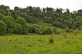 | 640 × 426 (114 KB) | GeographBot | == {{int:filedesc}} == {{Information |description={{en|1=Fraser Down Fraser Down was purchased by Surrey Wildlife Trust in 2008 after many years of negotiation with its owners. Although largely overrun with scrub, it has great potential as a link between |
File usage
The following pages on the English Wikipedia use this file (pages on other projects are not listed):