
File:Franklin CT Map 1811.png

Size of this preview: 650 × 599 pixels. Other resolutions: 260 × 240 pixels | 521 × 480 pixels | 770 × 710 pixels.
Original file (770 × 710 pixels, file size: 1.03 MB, MIME type: image/png)
| This is a file from the Wikimedia Commons. Information from its description page there is shown below. Commons is a freely licensed media file repository. You can help. |
Summary
| Description |
English: Detail from the 1811 Moses Warren and George Gillet map of Connecticut showing the Town of Franklin and its borders pre-1861. |
| Date | |
| Source | Library of Congress |
| Author | Warren, Moses, Gillet, George, Hudson & Goodwin |
Licensing
This work is in the public domain in the United States because it was published (or registered with the U.S. Copyright Office) before January 1, 1929.
Public domain works must be out of copyright in both the United States and in the source country of the work in order to be hosted on the Commons. If the work is not a U.S. work, the file must have an additional copyright tag indicating the copyright status in the source country.
Note: This tag should not be used for sound recordings. |
File history
Click on a date/time to view the file as it appeared at that time.
| Date/Time | Thumbnail | Dimensions | User | Comment | |
|---|---|---|---|---|---|
| current | 03:00, 3 December 2023 |  | 770 × 710 (1.03 MB) | CatharticHistorian | Got the entirety of Franklin this time. Missed the eastern notch. |
| 02:55, 3 December 2023 | 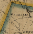 | 560 × 592 (651 KB) | CatharticHistorian | Uploaded a work by Warren, Moses, Gillet, George, Hudson & Goodwin from Library of Congress with UploadWizard |
File usage
The following pages on the English Wikipedia use this file (pages on other projects are not listed):