
File:Fountain Fire Temperature plot.png

Size of this preview: 527 × 599 pixels. Other resolutions: 211 × 240 pixels | 422 × 480 pixels | 675 × 768 pixels | 1,120 × 1,274 pixels.
Original file (1,120 × 1,274 pixels, file size: 278 KB, MIME type: image/png)
| This is a file from the Wikimedia Commons. Information from its description page there is shown below. Commons is a freely licensed media file repository. You can help. |
Summary
| Description |
English: A map of surface air temperature across North America, valid for 00Z, 1992-08-20. Generated using NCEP North American Regional Reanalysis (NARR) data provided by the NOAA PSL, Boulder, Colorado, USA, from their website at https://psl.noaa.gov |
| Date | |
| Source | https://psl.noaa.gov/data/gridded/data.narr.html |
| Author | NOAA Physical Sciences Laboratory |
Licensing
This image is in the public domain because it contains materials that originally came from the U.S. National Oceanic and Atmospheric Administration, taken or made as part of an employee's official duties.
|
File history
Click on a date/time to view the file as it appeared at that time.
| Date/Time | Thumbnail | Dimensions | User | Comment | |
|---|---|---|---|---|---|
| current | 19:24, 29 December 2022 | 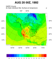 | 1,120 × 1,274 (278 KB) | Penitentes | Uploaded a work by NOAA Physical Sciences Laboratory from https://psl.noaa.gov/data/gridded/data.narr.html with UploadWizard |
File usage
The following pages on the English Wikipedia use this file (pages on other projects are not listed):