
File:Flooding June 2007 - geograph.org.uk - 722301.jpg

Size of this preview: 778 × 600 pixels. Other resolutions: 312 × 240 pixels | 623 × 480 pixels | 997 × 768 pixels | 1,280 × 987 pixels | 1,697 × 1,308 pixels.
Original file (1,697 × 1,308 pixels, file size: 2.48 MB, MIME type: image/jpeg)
| This is a file from the Wikimedia Commons. Information from its description page there is shown below. Commons is a freely licensed media file repository. You can help. |
This is a photo of listed building number 1162096. |
Summary
| Description |
English: Flooding June 2007, Wilberfoss, East Riding of Yorkshire, England. From point near the Church to a point near to the junction with Main Street Beckside was flooded to a depth where vehicles could not get through.See 1726550 |
| Date | |
| Source | From geograph.org.uk |
| Author | Keith Laverack |
| Permission (Reusing this file) |
Creative Commons Attribution Share-alike license 2.0 |
| Attribution (required by the license) | Keith Laverack / Flooding June 2007 / |
| Camera location | | View this and other nearby images on: OpenStreetMap |
|---|
| Object location | | View this and other nearby images on: OpenStreetMap |
|---|
Licensing

|
This image was taken from the Geograph project collection. See this photograph's page on the Geograph website for the photographer's contact details. The copyright on this image is owned by Keith Laverack and is licensed for reuse under the Creative Commons Attribution-ShareAlike 2.0 license.
|
This file is licensed under the Creative Commons Attribution-Share Alike 2.0 Generic license.
Attribution: Keith Laverack
- You are free:
- to share – to copy, distribute and transmit the work
- to remix – to adapt the work
- Under the following conditions:
- attribution – You must give appropriate credit, provide a link to the license, and indicate if changes were made. You may do so in any reasonable manner, but not in any way that suggests the licensor endorses you or your use.
- share alike – If you remix, transform, or build upon the material, you must distribute your contributions under the same or compatible license as the original.
File history
Click on a date/time to view the file as it appeared at that time.
| Date/Time | Thumbnail | Dimensions | User | Comment | |
|---|---|---|---|---|---|
| current | 19:59, 30 August 2017 | 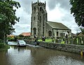 | 1,697 × 1,308 (2.48 MB) | Geograph Update Bot | Higher-resolution version from Geograph. |
| 04:38, 19 February 2011 | 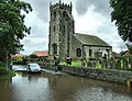 | 640 × 493 (125 KB) | GeographBot | == {{int:filedesc}} == {{Information |description={{en|1=Flooding June 2007 From point near the Church to a point near to the junction with Main Street Beckside was flooded to a depth where vehicles could not get through.See 1726550}} |date=2007-06-26 |
File usage
The following pages on the English Wikipedia use this file (pages on other projects are not listed):
Global file usage
The following other wikis use this file:
- Usage on ang.wikipedia.org