
File:First Irish farmers hut, Irish National Heritage Park - geograph.org.uk - 1252729.jpg
No higher resolution available.
First_Irish_farmers_hut,_Irish_National_Heritage_Park_-_geograph.org.uk_-_1252729.jpg (640 × 480 pixels, file size: 128 KB, MIME type: image/jpeg)
| This is a file from the Wikimedia Commons. Information from its description page there is shown below. Commons is a freely licensed media file repository. You can help. |
Summary
| Description |
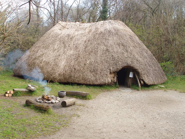
English: First Irish farmers hut, Irish National Heritage Park Around 4000 B.C. farmers came to Ireland and made permanent houses, raised livestock, grew cereals, and made pottery. In this exhibit in the Heritage Park a fire is lit on most days, some staff are in costumes of the various periods of Irish history, and on some days there are re-enactments of ancient life.
Première cabane d'agriculteurs irlandais. Le parc national du patrimoine irlandais vers 4000 avant J.-C., les agriculteurs sont venus en Irlande et ont construit des maisons permanentes, élevaient du bétail, ont planté des céréales, et faisaient de la poterie. Dans cette exposition dans le parc du patrimoine, un feu est allumé la plupart du temps, certains membres du personnel sont en costumes des différentes périodes de l'histoire irlandaise, et, certains jours, il y a des reconstitutions de la vie antique. |
| Date | |
| Source | From geograph.org.uk |
| Author | David Hawgood |
| Attribution (required by the license) | David Hawgood / First Irish farmers hut, Irish National Heritage Park / |
| Camera location | | View this and other nearby images on: OpenStreetMap |
|---|
| Object location | | View this and other nearby images on: OpenStreetMap |
|---|
Licensing

|
This image was taken from the Geograph project collection. See this photograph's page on the Geograph website for the photographer's contact details. The copyright on this image is owned by David Hawgood and is licensed for reuse under the Creative Commons Attribution-ShareAlike 2.0 license.
|
This file is licensed under the Creative Commons Attribution-Share Alike 2.0 Generic license.
Attribution: David Hawgood
- You are free:
- to share – to copy, distribute and transmit the work
- to remix – to adapt the work
- Under the following conditions:
- attribution – You must give appropriate credit, provide a link to the license, and indicate if changes were made. You may do so in any reasonable manner, but not in any way that suggests the licensor endorses you or your use.
- share alike – If you remix, transform, or build upon the material, you must distribute your contributions under the same or compatible license as the original.
File history
Click on a date/time to view the file as it appeared at that time.
| Date/Time | Thumbnail | Dimensions | User | Comment | |
|---|---|---|---|---|---|
| current | 19:56, 26 February 2011 |  | 640 × 480 (128 KB) | GeographBot | == {{int:filedesc}} == {{Information |description={{en|1=First Irish farmers hut, Irish National Heritage Park Around 4000 B.C. farmers came to Ireland and made permanent houses, raised livestock, grew cereals, and made pottery. In this exhibit in the Her |
File usage
The following pages on the English Wikipedia use this file (pages on other projects are not listed):
Global file usage
The following other wikis use this file:
- Usage on ga.wikipedia.org
- Usage on lfn.wikipedia.org
- Usage on nl.wikipedia.org
- Usage on pl.wikipedia.org
- Usage on pt.wikipedia.org
- Usage on sv.wikibooks.org