
File:Ferrocarril Central del Peru.jpg

Size of this preview: 696 × 599 pixels. Other resolutions: 279 × 240 pixels | 557 × 480 pixels | 843 × 726 pixels.
Original file (843 × 726 pixels, file size: 326 KB, MIME type: image/jpeg)
| This is a file from the Wikimedia Commons. Information from its description page there is shown below. Commons is a freely licensed media file repository. You can help. |


Summary
| Description |
English: Map of railway network of Ferrocarril Central in Peru (red lines).
Abandoned tracks are black, and the blue line is the Huancayo - Huancavelica line (state owned). |
| Date | |
| Source | Own modification of https://commons.wikimedia.org/wiki/File:Railways_in_Peru.svg |
| Author | Aldebaran |
| Other versions |
 |
Licensing
I, the copyright holder of this work, hereby publish it under the following licenses:

|
Permission is granted to copy, distribute and/or modify this document under the terms of the GNU Free Documentation License, Version 1.2 or any later version published by the Free Software Foundation; with no Invariant Sections, no Front-Cover Texts, and no Back-Cover Texts. A copy of the license is included in the section entitled GNU Free Documentation License. |
This file is licensed under the Creative Commons Attribution 3.0 Unported license.
- You are free:
- to share – to copy, distribute and transmit the work
- to remix – to adapt the work
- Under the following conditions:
- attribution – You must give appropriate credit, provide a link to the license, and indicate if changes were made. You may do so in any reasonable manner, but not in any way that suggests the licensor endorses you or your use.
You may select the license of your choice.
File history
Click on a date/time to view the file as it appeared at that time.
| Date/Time | Thumbnail | Dimensions | User | Comment | |
|---|---|---|---|---|---|
| current | 01:18, 14 March 2014 | 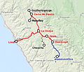 | 843 × 726 (326 KB) | Aldebaran | {{Information |Description ={{en|1=Map of railway network of Ferrocarril Central in Peru (red lines). Abandoned tracks are black, and the blue line is the Huancayo - Huancavelica line (state owned). }} |Source =Own modification of https://co... |
File usage
The following pages on the English Wikipedia use this file (pages on other projects are not listed):
Global file usage
The following other wikis use this file:
- Usage on de.wikipedia.org
- Usage on es.wikipedia.org
- Usage on fr.wikipedia.org
- Usage on no.wikipedia.org
- Usage on pl.wikipedia.org