
File:FederalTriangle 1851.jpg

Size of this preview: 800 × 425 pixels. Other resolutions: 320 × 170 pixels | 640 × 340 pixels | 1,260 × 669 pixels.
Original file (1,260 × 669 pixels, file size: 994 KB, MIME type: image/jpeg)
| This is a file from the Wikimedia Commons. Information from its description page there is shown below. Commons is a freely licensed media file repository. You can help. |
Summary
| Description |
English: Map of the city of Washington, D.C., published in 1851, showing the area around Federal Triangle as originally planned and built according to the L'Enfant Plan. |
|||||||||||||
| Date | ||||||||||||||
| Source | http://hdl.loc.gov/loc.gmd/g3850.ct000745 "Map of the city of Washington D.C.: established as the permanent seat of the government of the U.S. of Am. / James Keily, surveyor." Camden, N.J.: Lloyd Van Derveer, 1851. Library of Congress, Geography and Map Division. | |||||||||||||
| Author |
|
|||||||||||||
Only a portion of the original is used.
Licensing
This work is in the public domain in the United States because it was published (or registered with the U.S. Copyright Office) before January 1, 1929.
Public domain works must be out of copyright in both the United States and in the source country of the work in order to be hosted on the Commons. If the work is not a U.S. work, the file must have an additional copyright tag indicating the copyright status in the source country.
Note: This tag should not be used for sound recordings. |

|
This map is available from the United States Library of Congress's Geography & Map Division
under the digital ID g3850.ct000745. This tag does not indicate the copyright status of the attached work. A normal copyright tag is still required. See Commons:Licensing.
|
File history
Click on a date/time to view the file as it appeared at that time.
| Date/Time | Thumbnail | Dimensions | User | Comment | |
|---|---|---|---|---|---|
| current | 18:03, 23 November 2009 | 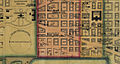 | 1,260 × 669 (994 KB) | Tim1965 | {{Information |Description={{en|1=Map of the city of Washington, D.C., published in 1851, showing the area around Federal Triangle as originally planned and built according to the L'Enfant Plan.}} |Source=http://hdl.loc.gov/loc.gmd/g3850.ct000745 "Map of |
File usage
The following pages on the English Wikipedia use this file (pages on other projects are not listed):