
File:FalmouthHarbour1777.png

No higher resolution available.
FalmouthHarbour1777.png (507 × 368 pixels, file size: 194 KB, MIME type: image/png)
| This is a file from the Wikimedia Commons. Information from its description page there is shown below. Commons is a freely licensed media file repository. You can help. |
Summary
| Description |
English: This is a detail from the source, which is a nautical chart. The full chart shows the 1777 town of Falmouth (now Portland), in Maine when it was still part of en:Massachusetts, Falmouth Harbour, and Portland Sound. This detail shows only Portland Sound, the town of Falmouth, and the Fore River area south of the town. |
| Date | |
| Source |
From the Boston Public Library Digital Maps Collection (maps.bpl.org): Call Number: G1106.P5 1777 .D4 URL at time of upload: http://maps.bpl.org/details_12630/ |
| Author | Des Barres, Joseph F.W. |
Licensing
|
This work is in the public domain in its country of origin and other countries and areas where the copyright term is the author's life plus 100 years or fewer. | |
| This file has been identified as being free of known restrictions under copyright law, including all related and neighboring rights. | |
File history
Click on a date/time to view the file as it appeared at that time.
| Date/Time | Thumbnail | Dimensions | User | Comment | |
|---|---|---|---|---|---|
| current | 14:17, 26 January 2009 | 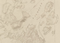 | 507 × 368 (194 KB) | Magicpiano | Cropped version. |
| 14:15, 26 January 2009 |  | 1,280 × 800 (557 KB) | Magicpiano | {{Information |Description={{en|1=This is a detail from the source, which is a nautical chart. The full chart shows the 1777 town of Falmouth (now Portland), in Maine when it was still part of en:Massachusetts, |
File usage
The following pages on the English Wikipedia use this file (pages on other projects are not listed):
Global file usage
The following other wikis use this file:
- Usage on et.wikipedia.org
- Usage on fr.wikipedia.org
- Usage on ja.wikipedia.org
- Usage on ru.wikipedia.org