
File:Eurovision participation map.svg
Size of this PNG preview of this SVG file: 680 × 540 pixels. Other resolutions: 302 × 240 pixels | 605 × 480 pixels | 967 × 768 pixels | 1,280 × 1,016 pixels | 2,560 × 2,033 pixels.
Original file (SVG file, nominally 680 × 540 pixels, file size: 1.47 MB)
| This is a file from the Wikimedia Commons. Information from its description page there is shown below. Commons is a freely licensed media file repository. You can help. |
Summary
| Description |
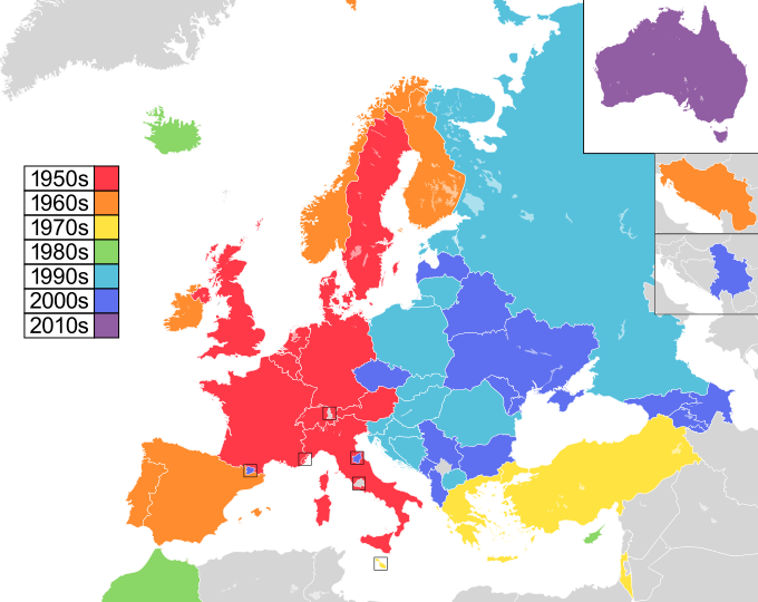
English: Updated version of a map showing European countries highlighted by the decade in which they participated in the Eurovision Song Contest for the first time, originally derived from File:Eurovision participation map.png.
1950s
1960s
1970s
1980s
1990s
2000s
2010s
2020s Русский: Карта стран-участниц конкурса песни «Евровидения», на которой указаны страны, дебютирующие на конкурсе и отсортированные по десятилетиям. Карта основана на Eurovision participation map.png.
1950-е
1960-е
1970-е
1980-е
1990-е
2000-е
2010-е
2020-е |
| Date | (UTC) |
| Source | Own work. Participants list on official Eurovision website. |
| Author | Sims2aholic8 (Michael) (talk) |
| Other versions | File:Eurovision participation map.png (original png version) |
Licensing
| This work has been released into the public domain by its author, Sims2aholic8 at English Wikipedia. This applies worldwide. In some countries this may not be legally possible; if so: Sims2aholic8 grants anyone the right to use this work for any purpose, without any conditions, unless such conditions are required by law. |
Original upload log
The original description page was here. All following user names refer to en.wikipedia.
- 2009-12-12 17:20 Sims2aholic8 680×540× (576881 bytes) Update
- 2009-12-12 17:11 Sims2aholic8 680×540× (577159 bytes) {{Information |Description = Updated version of a map showing European countries highlighted by the decade in which they participated in the [[w:Eurovision Song Contest|Eurovision Song Contest]] for the first time, originally derived from [[File:Eurov
File history
Click on a date/time to view the file as it appeared at that time.
| Date/Time | Thumbnail | Dimensions | User | Comment | |
|---|---|---|---|---|---|
| current | 22:20, 17 March 2024 |  | 680 × 540 (1.47 MB) | ImStevan | updated with new map |
| 09:50, 16 June 2016 |  | 680 × 540 (405 KB) | Alex Great | Making hatches with clipping pathes, removed Canaries, changes position of Australia, fixed borders of Russia | |
| 02:59, 13 April 2015 |  | 680 × 540 (401 KB) | Leftcry | Macedonia | |
| 15:41, 12 February 2015 |  | 680 × 540 (396 KB) | Santwyne | portugal fixed | |
| 15:36, 12 February 2015 |  | 680 × 540 (396 KB) | Santwyne | outlined text to avoid awkward substitution | |
| 15:33, 12 February 2015 |  | 680 × 540 (370 KB) | Santwyne | added australia, added key to match with other eurovision map style, new colour scheme. | |
| 13:20, 25 November 2012 |  | 680 × 540 (563 KB) | D97v | Monaco | |
| 20:25, 4 June 2010 |  | 680 × 540 (563 KB) | File Upload Bot (Magnus Manske) | {{BotMoveToCommons|en.wikipedia|year={{subst:CURRENTYEAR}}|month={{subst:CURRENTMONTHNAME}}|day={{subst:CURRENTDAY}}}} {{Information |Description={{en|Updated version of a map showing European countries highlighted by the decade in which they participate |
File usage
The following pages on the English Wikipedia use this file (pages on other projects are not listed):
Global file usage
The following other wikis use this file:
- Usage on af.wikipedia.org
- Usage on az.wikipedia.org
- Usage on cs.wikipedia.org
- Usage on el.wikipedia.org
- Usage on et.wikipedia.org
- Usage on fr.wikipedia.org
- Usage on hu.wikipedia.org
- Usage on hy.wikipedia.org
- Usage on id.wikipedia.org
- Usage on it.wikipedia.org
- Usage on ja.wikipedia.org
- Usage on lv.wikipedia.org
- Usage on mk.wikipedia.org
- Usage on ms.wikipedia.org
- Usage on mt.wikipedia.org
- Usage on nn.wikipedia.org
- Usage on pl.wikipedia.org
- Usage on pt.wikipedia.org
- Usage on ru.wikipedia.org
- Usage on sq.wikipedia.org
- Usage on sv.wikipedia.org
- Usage on tr.wikipedia.org
- Usage on uk.wikipedia.org
- Usage on zh.wikipedia.org