
File:ElectoralCollege1820.svg

Size of this PNG preview of this SVG file: 577 × 593 pixels. Other resolutions: 234 × 240 pixels | 467 × 480 pixels | 747 × 768 pixels | 996 × 1,024 pixels | 1,993 × 2,048 pixels.
Original file (SVG file, nominally 577 × 593 pixels, file size: 170 KB)
| This is a file from the Wikimedia Commons. Information from its description page there is shown below. Commons is a freely licensed media file repository. You can help. |
| U.S. presidential election maps (SVG) |
| See also: National Atlas maps (png) |
|
1789 · 1792 · 1796 · 1800 · 1804 · 1808 · 1812 · 1816 · 1820 · 1824 · 1828 · 1832 · 1836 · 1840 · 1844 · 1848 · 1852 · 1856 · 1860 · 1864 · 1868 · 1872 · 1876 · 1880 · 1884 · 1888 · 1892 · 1896 · 1900 · 1904 · 1908 · 1912 · 1916 · 1920 · 1924 · 1928 · 1932 · 1936 · 1940 · 1944 · 1948 · 1952 · 1956 · 1960 · 1964 · 1968 · 1972 · 1976 · 1980 · 1984 · 1988 · 1992 · 1996 · 2000 · 2004 · 2008 · 2012 · 2016 · 2020 · 2024 |
Summary
| Description |
English: Electoral college map for the 1820 United States presidential election. *Missouri's statehood status and subsequent electoral votes are disputed. |
| Date | (Original); 2009-01-16 (Current) |
| Source | This image was adapted from File:ElectoralCollege1804.svg, itself adapted from File:Map of territorial growth 1775.svg and File:ElectoralCollege1964.svg (both based off File:Blank_US_Map.svg) using data from File:ElectoralCollege1820-Large.png, File:United States 1820-1821-07.png, the original version uploaded by AndyHogan14 and the National Atlas of the United States |
| Author |
Cg-realms (current) AndyHogan14 (original) |
| Other versions | File:ElectoralCollege1820-Large.png |
| SVG development | W3C-validity not checked. |
Licensing
| I, the copyright holder of this work, release this work into the public domain. This applies worldwide. In some countries this may not be legally possible; if so: I grant anyone the right to use this work for any purpose, without any conditions, unless such conditions are required by law. |
File history
Click on a date/time to view the file as it appeared at that time.
| Date/Time | Thumbnail | Dimensions | User | Comment | |
|---|---|---|---|---|---|
| current | 22:33, 11 July 2018 |  | 577 × 593 (170 KB) | Wow | fix |
| 22:15, 11 July 2018 |  | 577 × 593 (161 KB) | Wow | NH | |
| 22:15, 11 July 2018 |  | 577 × 593 (161 KB) | Wow | NH | |
| 22:09, 11 July 2018 | 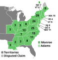 | 577 × 593 (161 KB) | Wow | MI | |
| 02:21, 27 December 2016 |  | 577 × 593 (100 KB) | Wow | Adams | |
| 06:14, 14 November 2016 |  | 577 × 593 (100 KB) | Wow | Names | |
| 06:13, 14 November 2016 |  | 577 × 593 (100 KB) | Wow | Territories | |
| 01:28, 18 December 2012 | 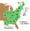 | 577 × 593 (100 KB) | Hous21 | Corrected IL (3) and ME (9) delegates | |
| 20:01, 23 February 2011 |  | 577 × 593 (100 KB) | Cg-realms | Tennessee: Corrected electoral count to 7 votes from 8. TN had 8 electoral votes, but one elector died before casting his. Maryland: Corrected electoral count to 11 votes from 8. A typo made adapting 1816 map to 1820 election. | |
| 02:45, 17 January 2009 |  | 577 × 593 (100 KB) | Cg-realms | More accurate version of quasi-statehood Missouri |
File usage
The following pages on the English Wikipedia use this file (pages on other projects are not listed):
- 1820 United States elections
- 1820 United States presidential election
- 1820 United States presidential election in Alabama
- 1820 United States presidential election in Connecticut
- 1820 United States presidential election in Indiana
- 1820 United States presidential election in Louisiana
- 1820 United States presidential election in Maryland
- 1820 United States presidential election in Massachusetts
- 1820 United States presidential election in Missouri
- 1820 United States presidential election in New Hampshire
- 1820 United States presidential election in New Jersey
- 1820 United States presidential election in New York
- 1820 United States presidential election in Ohio
- 1820 United States presidential election in Pennsylvania
- 1820 United States presidential election in South Carolina
- 1820 United States presidential election in Vermont
- Electoral vote changes between United States presidential elections
- List of United States presidential election results by state
- Presidency of James Monroe
- United States presidential election
- User:DukeOfDelTaco/U.S. Presidential Elections
- Template:1820 United States presidential election imagemap
- Template:State results of the 1820 U.S. presidential election
Global file usage
The following other wikis use this file:
- Usage on da.wikipedia.org
- Usage on de.wikipedia.org
- Usage on el.wikipedia.org
- Usage on es.wikipedia.org
- Usage on fa.wikipedia.org
- Usage on fi.wikipedia.org
- Usage on fr.wikipedia.org
- Usage on he.wikipedia.org
- Usage on it.wikipedia.org
- Usage on ja.wikipedia.org
- Usage on ka.wikipedia.org
- Usage on ko.wikipedia.org
- Usage on mk.wikipedia.org
- Usage on pl.wikipedia.org
- Usage on ru.wikipedia.org
- Usage on sv.wikipedia.org
- Usage on tr.wikipedia.org
- Usage on vi.wikipedia.org
- Usage on zh.wikipedia.org