
File:Elayet of temesvar.png

Size of this preview: 464 × 599 pixels. Other resolutions: 186 × 240 pixels | 372 × 480 pixels | 833 × 1,075 pixels.
Original file (833 × 1,075 pixels, file size: 123 KB, MIME type: image/png)
| This is a file from the Wikimedia Commons. Information from its description page there is shown below. Commons is a freely licensed media file repository. You can help. |
Summary
| Description |
English: historic map of the Eyalet of Temeşvar, Sanjak of Sirem and Sanjak of Segedin
Српски / srpski: историјска мапа Темишварског пашалука, Сремског санџака и Сегединског санџака |
| Date | 28 December 2006 (original upload date) |
| Source | Own work |
| Author | PANONIAN |
References
- Petrit Imami, Srbi i Albanci kroz vekove, Beograd, 2000.
- The Times History of Europe, Times Books, 2002.
- Istorijski atlas, Zavod za udžbenike i nastavna sredstva - Zavod za kartografiju "Geokarta", Beograd, 1999.
- Milan Tutorov, Banatska rapsodija - istorika Zrenjanina i Banata, Novi Sad, 2001.
- Peter Rokai - Zoltan Đere - Tibor Pal - Aleksandar Kasaš, Istorija Mađara, Beograd, 2002.
- Dr Dušan J. Popović, Srbi u Vojvodini, knjiga 1, Novi Sad, 1990.
- Sima M. Ćirković, Srbi među evropskim narodima, Beograd, 2004.
- Milutin Perović - Relja Novaković, Istorija za III razred gimnazije (opšti tip i društveno-jezički smer) i stručnih škola, Beograd, 1997.
- Milutin Perović - Milo Strugar, Istorija za 7. razred osnovne škole, Beograd - Novi Sad, 1993.
- Sima Ćirković, Istorija za II razred gimnazije prirodno-matematičkog smera, Beograd, 1997.
Source and licence

|
This map has been uploaded by Electionworld from en.wikipedia.org to enable the |
self made map by user:PANONIAN
Licensing
| I, the copyright holder of this work, release this work into the public domain. This applies worldwide. In some countries this may not be legally possible; if so: I grant anyone the right to use this work for any purpose, without any conditions, unless such conditions are required by law. |
File history
Click on a date/time to view the file as it appeared at that time.
| Date/Time | Thumbnail | Dimensions | User | Comment | |
|---|---|---|---|---|---|
| current | 21:04, 14 September 2013 |  | 833 × 1,075 (123 KB) | PANONIAN | aesthetics |
| 19:40, 5 September 2013 | 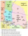 | 833 × 1,075 (127 KB) | PANONIAN | minor changes | |
| 21:02, 22 March 2009 | 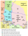 | 837 × 1,077 (128 KB) | PANONIAN | ||
| 18:59, 28 December 2006 | 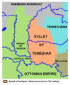 | 480 × 582 (11 KB) | Electionworld | {{ew|en|PANONIAN}} historic map of the Eyalet of Temeşvar (self made) {{PD-self}} Category:Maps of the history of Romania Category:Maps of the history of Serbia Category:Maps of the history of Vojvodina |
File usage
The following pages on the English Wikipedia use this file (pages on other projects are not listed):
Global file usage
The following other wikis use this file:
- Usage on az.wikipedia.org
- Usage on bs.wikipedia.org
- Usage on ca.wikipedia.org
- Usage on de.wikipedia.org
- Usage on el.wikipedia.org
- Usage on fi.wikipedia.org
- Usage on fr.wikipedia.org
- Usage on gl.wikipedia.org
- Usage on he.wikipedia.org
- Usage on hr.wikipedia.org
- Usage on it.wikipedia.org
- Usage on ja.wikipedia.org
- Usage on pt.wikipedia.org
- Usage on ro.wikipedia.org
- Usage on ru.wikipedia.org
- Usage on sh.wikipedia.org
- Usage on uk.wikipedia.org