
File:Economic region of Herzegovina.png
Size of this preview: 631 × 599 pixels. Other resolutions: 253 × 240 pixels | 505 × 480 pixels | 808 × 768 pixels | 1,078 × 1,024 pixels | 1,600 × 1,520 pixels.
Original file (1,600 × 1,520 pixels, file size: 129 KB, MIME type: image/png)
| This is a file from the Wikimedia Commons. Information from its description page there is shown below. Commons is a freely licensed media file repository. You can help. |
Summary
| Description |
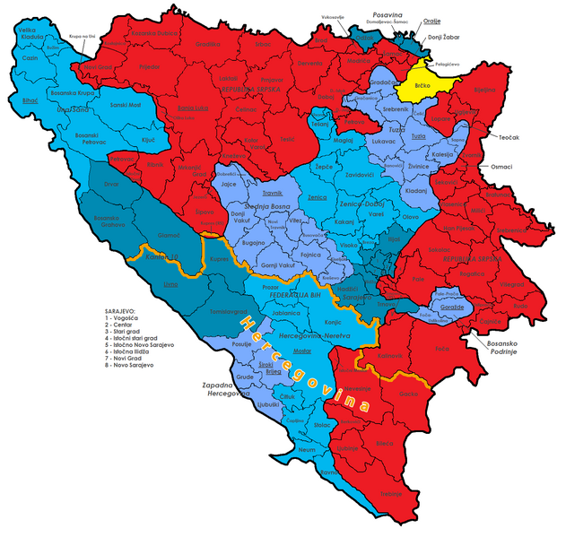
Deutsch: Diese Karte zeigt die Verwaltungsgliederung von Bosnien und Herzegowina. Dargestellt sind die Föderation BiH (blau) mit ihren Kantonen (verschiedene Schattierungen) und deren Hauptstädten, die Republika Srpska (rot), der Brčko-Distrikt (gelb) und alle Gemeinden mit ihren offiziellen Namen. Die Wirtschaftsregion Herzegowina ist orange abgegrenzt.
English: Map of the political division of Bosnia and Herzegovina; shows Federation Bih (blue) with cantons (different colours), Republika Srpska (red), Brčko district (yellow) and all municipalities with their official names. The Economical Region of Herzegovina is highlighted in orange. |
||
| Date | (UTC) | ||
| Source |
|
||
| Author |
|
||
| Other versions |
|


|
This map has been made or improved in the German Kartenwerkstatt (Map Lab). You can propose maps to improve as well.
|
Licensing
This file is licensed under the Creative Commons Attribution-Share Alike 3.0 Unported license.
- You are free:
- to share – to copy, distribute and transmit the work
- to remix – to adapt the work
- Under the following conditions:
- attribution – You must give appropriate credit, provide a link to the license, and indicate if changes were made. You may do so in any reasonable manner, but not in any way that suggests the licensor endorses you or your use.
- share alike – If you remix, transform, or build upon the material, you must distribute your contributions under the same or compatible license as the original.
Original upload log
This image is a derivative work of the following images:
- File:Bosnia_and_Herzegovina_Political.png licensed with Cc-by-sa-3.0,2.5,2.0,1.0, GFDL
- 2009-07-18T16:15:19Z J budissin 1600x1520 (205343 Bytes) {{Information |Description= {{en|Map of the political division of Bosnia and Herzegovina; shows Federation Bih (blue) with cantons (different colours), Republika Srpska (red), Brčko district (yellow) and all municipalities w
File history
Click on a date/time to view the file as it appeared at that time.
| Date/Time | Thumbnail | Dimensions | User | Comment | |
|---|---|---|---|---|---|
| current | 19:37, 1 August 2013 |  | 1,600 × 1,520 (129 KB) | NordNordWest | c |
| 19:49, 31 July 2013 |  | 1,600 × 1,520 (128 KB) | NordNordWest | == {{int:filedesc}} == {{Information |Description={{de|Diese Karte zeigt die Verwaltungsgliederung von Bosnien und Herzegowina. Dargestellt sind die Föderation BiH (blau) mit ihren Kantonen (verschiedene Schattierungen) und deren Hauptstädten, die Re... |
File usage
The following pages on the English Wikipedia use this file (pages on other projects are not listed):
Global file usage
The following other wikis use this file:
- Usage on de.wikipedia.org
- Usage on mk.wikipedia.org
- Usage on sh.wikipedia.org
- Usage on sq.wikipedia.org