
File:EF3 tornado damage in Bowling Green, Kentucky.jpg
No higher resolution available.
EF3_tornado_damage_in_Bowling_Green,_Kentucky.jpg (640 × 480 pixels, file size: 143 KB, MIME type: image/jpeg)
| This is a file from the Wikimedia Commons. Information from its description page there is shown below. Commons is a freely licensed media file repository. You can help. |
Summary
| Description |
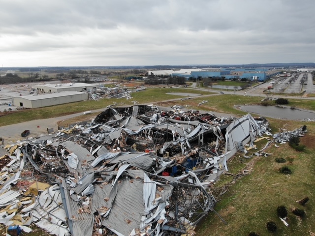
English: EF3 tornado damage inflicted to a metal building system northeast of Bowling Green, Kentucky. This tornado impacted downtown portions of the city shortly before an EF2 tornado moved through the southeastern sections. |
| Date | |
| Source | https://apps.dat.noaa.gov/stormdamage/damageviewer/ |
| Author | National Weather Service |
| Camera location | | View this and other nearby images on: OpenStreetMap |
|---|
Licensing
This image is in the public domain because it was stored on the web servers of the U.S. National Weather Service. NWS-created images are automatically public domain in the U.S. since the NWS is a part of the U.S. government. However, the NWS sites also host non-NWS images which have been submitted by individuals: these are generally shown as "Courtesy of ...". Such images have explicitly been released to the public domain by the copyright owner as part of the upload process.
As stated at https://www.weather.gov/fsd/disclaimer: "By submitting images, you understand that your image is being released into the public domain. This means that your photo or video may be downloaded, copied, and used by others." Thus, all* images on NWS servers are public domain (including "Courtesy of ..." and “Photo by ...” images) unless specifically stated otherwise through a copyright (©) watermark.
*A deletion discussion in November 2023 ruled that Getty Images on the web servers of NWS, are to be considered copyrighted, even without a copyright (©) watermark and are the sole exception to this rule.
|
File history
Click on a date/time to view the file as it appeared at that time.
| Date/Time | Thumbnail | Dimensions | User | Comment | |
|---|---|---|---|---|---|
| current | 05:22, 24 December 2021 |  | 640 × 480 (143 KB) | Wxtrackercody | Uploaded a work by National Weather Service from https://apps.dat.noaa.gov/stormdamage/damageviewer/ with UploadWizard |
File usage
The following pages on the English Wikipedia use this file (pages on other projects are not listed):