
File:EF2 damage Kirby, AR March 2023.jpg

Size of this preview: 800 × 600 pixels. Other resolutions: 320 × 240 pixels | 640 × 480 pixels | 1,024 × 768 pixels | 1,280 × 960 pixels | 2,560 × 1,920 pixels | 3,264 × 2,448 pixels.
Original file (3,264 × 2,448 pixels, file size: 3.42 MB, MIME type: image/jpeg)
| This is a file from the Wikimedia Commons. Information from its description page there is shown below. Commons is a freely licensed media file repository. You can help. |
Summary
| Description |
English: A mobile home that was destroyed after being rolled and tossed into a tree line by a high-end EF2 tornado near Kirby, Arkansas on March 2, 2023. Two of the four occupants suffered minor injuries.
"Mobile home was secured with tie down straps, and was rolled and tossed around 100 feet, completely destroying the unit. Two minor injuries were noted among the four occupants." |
| Date | |
| Source | https://services.dat.noaa.gov/arcgis/rest/services/nws_damageassessmenttoolkit/DamageViewer/FeatureServer/0/3445383/attachments/2098789 |
| Author | NWS Little Rock AR |
| Camera location | | View this and other nearby images on: OpenStreetMap |
|---|
Licensing
This image is in the public domain because it contains materials that originally came from the U.S. National Oceanic and Atmospheric Administration, taken or made as part of an employee's official duties.
|
File history
Click on a date/time to view the file as it appeared at that time.
| Date/Time | Thumbnail | Dimensions | User | Comment | |
|---|---|---|---|---|---|
| current | 16:51, 7 March 2023 | 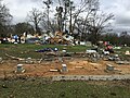 | 3,264 × 2,448 (3.42 MB) | ChessEric | Uploaded a work by NWS Little Rock AR from https://services.dat.noaa.gov/arcgis/rest/services/nws_damageassessmenttoolkit/DamageViewer/FeatureServer/0/3445383/attachments/2098789 with UploadWizard |
File usage
The following pages on the English Wikipedia use this file (pages on other projects are not listed):