
File:Dunsbear holt railway station.jpg

No higher resolution available.
Dunsbear_holt_railway_station.jpg (640 × 427 pixels, file size: 140 KB, MIME type: image/jpeg)
| This is a file from the Wikimedia Commons. Information from its description page there is shown below. Commons is a freely licensed media file repository. You can help. |
Summary
| Description |
English: Dunsbear Halt Dunsbear Halt was the most used of all the halts on the Torrington to Halwill line (now part of the Tarka Trail cycle route), largely because it was the closest to one of the china clay works and attracted a certain amount of commuter traffic. The sculpture on the right was made of tiles by local schoolchildren. |
| Date | |
| Source | From geograph.org.uk |
| Author | Ron Strutt |
| Permission (Reusing this file) |
Creative Commons Attribution Share-alike license 2.0 |
| Attribution (required by the license) | Ron Strutt / Dunsbear Halt / |
| Object location | | View this and other nearby images on: OpenStreetMap |
|---|
Licensing

|
This image was taken from the Geograph project collection. See this photograph's page on the Geograph website for the photographer's contact details. The copyright on this image is owned by Ron Strutt and is licensed for reuse under the Creative Commons Attribution-ShareAlike 2.0 license.
|
This file is licensed under the Creative Commons Attribution-Share Alike 2.0 Generic license.
Attribution: Ron Strutt
- You are free:
- to share – to copy, distribute and transmit the work
- to remix – to adapt the work
- Under the following conditions:
- attribution – You must give appropriate credit, provide a link to the license, and indicate if changes were made. You may do so in any reasonable manner, but not in any way that suggests the licensor endorses you or your use.
- share alike – If you remix, transform, or build upon the material, you must distribute your contributions under the same or compatible license as the original.
Original upload log
The original description page was here. All following user names refer to en.wikipedia.
- 2007-10-26 16:27 Bashereyre 640×427× (143347 bytes) Ron Strutt Date Taken Tuesday, 2 September, 2003 Submitted “Photograph every grid square” on Wednesday, 28 September, 2005 via Creative commons
File history
Click on a date/time to view the file as it appeared at that time.
| Date/Time | Thumbnail | Dimensions | User | Comment | |
|---|---|---|---|---|---|
| current | 09:48, 30 May 2009 | 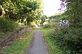 | 640 × 427 (140 KB) | File Upload Bot (Magnus Manske) | {{BotMoveToCommons|en.wikipedia|year={{subst:CURRENTYEAR}}|month={{subst:CURRENTMONTHNAME}}|day={{subst:CURRENTDAY}}}} {{Information |Description={{en|Ron Strutt Date Taken Tuesday, 2 September, 2003 Submitted “Photograph every grid square” on Wed |
File usage
The following pages on the English Wikipedia use this file (pages on other projects are not listed):