
File:Dublin City Boundaries 2020.png
Size of this preview: 617 × 600 pixels. Other resolutions: 247 × 240 pixels | 494 × 480 pixels | 790 × 768 pixels | 1,054 × 1,024 pixels | 2,552 × 2,480 pixels.
Original file (2,552 × 2,480 pixels, file size: 484 KB, MIME type: image/png)
| This is a file from the Wikimedia Commons. Information from its description page there is shown below. Commons is a freely licensed media file repository. You can help. |
Summary
| Description |
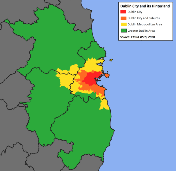
English: The Boundaries of Dublin City, its suburbs, the Dublin Metropolitan Area (DMA) and the Greater Dublin Area (GDA) as defined in the Eastern and Midland Regional Assembly's Regional, Spatial and Economic Strategy (RSES) 2019-2031, published in early 2020. |
| Date | |
| Source | Own work |
| Author | Jacobfrid |
Licensing
I, the copyright holder of this work, hereby publish it under the following license:
This file is licensed under the Creative Commons Attribution-Share Alike 4.0 International license.
- You are free:
- to share – to copy, distribute and transmit the work
- to remix – to adapt the work
- Under the following conditions:
- attribution – You must give appropriate credit, provide a link to the license, and indicate if changes were made. You may do so in any reasonable manner, but not in any way that suggests the licensor endorses you or your use.
- share alike – If you remix, transform, or build upon the material, you must distribute your contributions under the same or compatible license as the original.
File history
Click on a date/time to view the file as it appeared at that time.
| Date/Time | Thumbnail | Dimensions | User | Comment | |
|---|---|---|---|---|---|
| current | 13:30, 6 July 2022 |  | 2,552 × 2,480 (484 KB) | Jacobfrid | Update boundaries to reflect more accurate Dublin SPA Socio-Economic Evidence Baseline Report, Nov 2017 version of the DMA |
| 10:49, 29 September 2020 |  | 2,552 × 2,480 (487 KB) | Jacobfrid | Reverted to version as of 09:17, 29 September 2020 (UTC) | |
| 10:49, 29 September 2020 |  | 2,552 × 2,480 (486 KB) | Jacobfrid | re | |
| 09:17, 29 September 2020 |  | 2,552 × 2,480 (487 KB) | Jacobfrid | Remove green area in Dublin city | |
| 07:10, 18 July 2020 |  | 2,552 × 2,480 (385 KB) | Jacobfrid | Change overlay order to show Kildare / Meath county boundaries over DMA boundary | |
| 16:23, 17 July 2020 |  | 2,408 × 2,476 (366 KB) | Jacobfrid | Uploaded own work with UploadWizard |
File usage
The following pages on the English Wikipedia use this file (pages on other projects are not listed):