
File:Disputed areas in Iraq.svg

Size of this PNG preview of this SVG file: 520 × 600 pixels. Other resolutions: 208 × 240 pixels | 416 × 480 pixels | 666 × 768 pixels | 887 × 1,024 pixels | 1,775 × 2,048 pixels | 650 × 750 pixels.
Original file (SVG file, nominally 650 × 750 pixels, file size: 432 KB)
| This is a file from the Wikimedia Commons. Information from its description page there is shown below. Commons is a freely licensed media file repository. You can help. |
Summary
| Description |
English: Disputed areas in Iraq according to article 140 of the Iraqi Constitution:
Undisputed and part of the Kurdish Regional Government since 1991.
Undisputed and under the control of central government.
Disputed and part of the Kurdish Regional Government since 1991.
Disputed and under the control of central government. کوردی: ناوچە جێناکۆکەکان بەپێی ماددەی ١٤٠ی دەستووری عێراق:
ناجێناکۆک و بەشێک لەهەرێمی کوردستان لە ١٩٩١ەوە
ناجێناکۆک و لەژێر کۆنترۆڵی حکوومەتی عێراقی
جێناکۆک و بەشێک لە هەرێمی کوردستان لە ١٩٩١ەوە
جێناکۆک و لەژێر کۆنترۆڵی حکوومەتی عێراقی |
| Date | |
| Source |
Own work This vector image includes elements that have been taken or adapted from this file: |
| Author | Rafy |
| Other versions |
| This SVG file contains embedded text that can be translated into your language, using any capable SVG editor, text editor or the SVG Translate tool. For more information see: About translating SVG files. |
This W3C-unspecified vector image was created with Inkscape .
Licensing
I, the copyright holder of this work, hereby publish it under the following licenses:

|
Permission is granted to copy, distribute and/or modify this document under the terms of the GNU Free Documentation License, Version 1.2 or any later version published by the Free Software Foundation; with no Invariant Sections, no Front-Cover Texts, and no Back-Cover Texts. A copy of the license is included in the section entitled GNU Free Documentation License. |
This file is licensed under the Creative Commons Attribution-Share Alike 3.0 Unported license.
- You are free:
- to share – to copy, distribute and transmit the work
- to remix – to adapt the work
- Under the following conditions:
- attribution – You must give appropriate credit, provide a link to the license, and indicate if changes were made. You may do so in any reasonable manner, but not in any way that suggests the licensor endorses you or your use.
- share alike – If you remix, transform, or build upon the material, you must distribute your contributions under the same or compatible license as the original.
You may select the license of your choice.
File history
Click on a date/time to view the file as it appeared at that time.
| Date/Time | Thumbnail | Dimensions | User | Comment | |
|---|---|---|---|---|---|
| current | 13:16, 8 November 2017 | 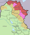 | 650 × 750 (432 KB) | Rob984 | Reverted to version as of 14:38, 7 November 2011 (UTC) This map illutrates the siutation before Halabja became a province. Also those boundaries for Halabja are wrong. |
| 16:09, 27 June 2014 |  | 650 × 750 (434 KB) | Nightstallion | Reverted to version as of 02:59, 13 June 2014, Halabja | |
| 11:14, 25 June 2014 |  | 650 × 750 (432 KB) | Kathovo | Reverted to version as of 10:47, 25 June 2014, You have changed the scope with this edit, please refer to COM:UPLOADWAR | |
| 11:04, 25 June 2014 | 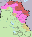 | 650 × 750 (434 KB) | Spesh531 | Reverted to version as of 23:47, 20 June 2014 Disputed areas are still being shown according to Article 140, the administrator has changed sides, however. it would not follow article 140 of the red | |
| 10:47, 25 June 2014 |  | 650 × 750 (432 KB) | Kathovo | Reverted to version as of 14:38, 7 November 2011 map is meant to show areas designated by the Article 140 of the Iraqi Constitution | |
| 23:47, 20 June 2014 |  | 650 × 750 (434 KB) | Spesh531 | no info on baaj | |
| 19:47, 17 June 2014 | 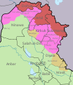 | 650 × 750 (438 KB) | Spesh531 | areas are controlled by Kurdistan are now pink | |
| 15:41, 13 June 2014 | 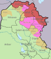 | 650 × 750 (448 KB) | Haghal Jagul | After the ISIS invasion and its detailed developments | |
| 02:59, 13 June 2014 |  | 650 × 750 (434 KB) | Spesh531 | with Halabja | |
| 14:38, 7 November 2011 | 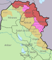 | 650 × 750 (432 KB) | Kathovo |
File usage
The following pages on the English Wikipedia use this file (pages on other projects are not listed):
Global file usage
The following other wikis use this file:
- Usage on ar.wikipedia.org
- Usage on ast.wikipedia.org
- Usage on azb.wikipedia.org
- Usage on az.wikipedia.org
- Usage on be-tarask.wikipedia.org
- Usage on be.wikipedia.org
- Usage on ckb.wikipedia.org
- Usage on es.wikipedia.org
- Usage on fa.wikipedia.org
- Usage on fi.wikipedia.org
- Usage on he.wikipedia.org
- Usage on sv.wikipedia.org